
Geographic Region: BOLIVIA
Feature: PARAPETI RIVER,AGRICULTURAL FIELDS
|
Geographic Region: BOLIVIA Feature: PARAPETI RIVER,AGRICULTURAL FIELDS |
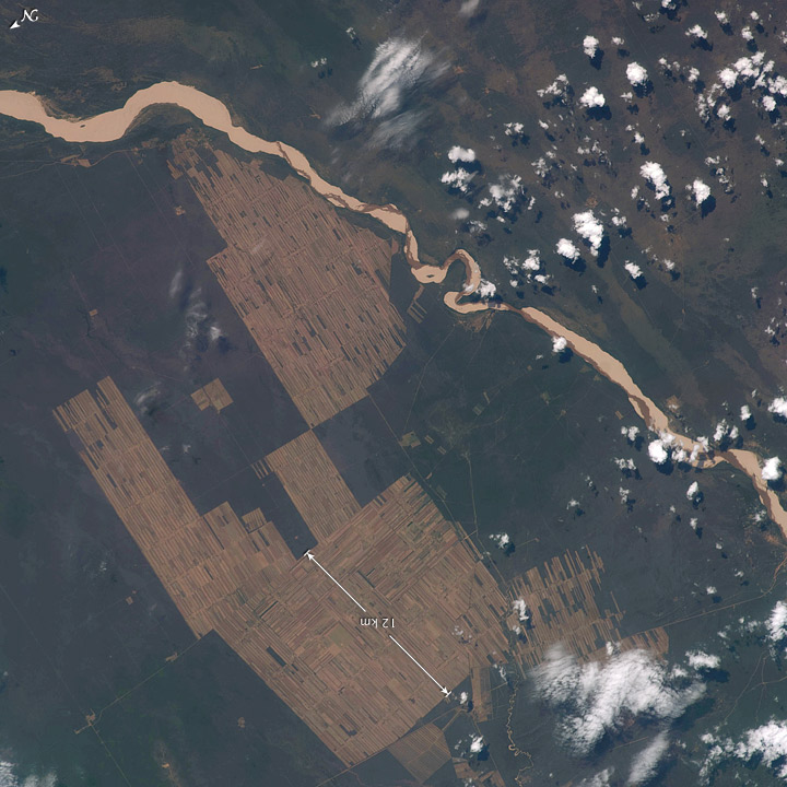 |
| Progressive Forest Clearing, Bolivia The eastern half of Bolivia is covered with tropical rainforest. In the 1990s, Bolivia initiated a large-scale effort to increase the rate of logging and create tracts of land for commercial agriculture (primarily soy and sugar cane, but also cocoa) on the Amazon Basin side of the Andean highlands. Today, the commercial fields are well established and easily mapped from space as large, rectangular clearings in the forest. The agricultural developments are still growing today. The clearings start off as small rectangles arranged perpendicular to an access road; early clearings take on a herringbone pattern when viewed from above. The intact areas (dark forest) are gradually logged and then cultivated, filling in the pattern to make a larger cleared area. Astronauts aboard the International Space Station (ISS) routinely observe intensive land use and document their observations through imagery so that changes can be identified. These two photographs of the Bolivian forest along the Rio Parapeti in Bolivia (south of Santa Cruz, not shown) show different stages of the clearing process and agricultural field development. The top image, a wide panoramic view looking toward the west and the Andean foothills, was taken from the Space Shuttle in November 1995. The clearing efforts were just getting underway, evidenced by the crosshatched and herringbone pattern of clearing north of the river. On the south side of the river, old, abandoned stream channels show up as lighter regions with lesser forest cover. The bottom view, a composite of two images taken from the ISS, provides a more detailed view of today's landscape, showing completely cleared regions that stretch for more than 10 kilometers. For scale, the white line is about 12 kilometers (7.5 miles). The geographic area covered in the 2008 view is approximated on the top image by the white box. |
| Images: | All Available Images Low-Resolution 154k |
|
| Mission: | ISS018 |
|
| Roll - Frame: | E - 8064 |
|
| Geographical Name: | BOLIVIA |
|
| Features: | PARAPETI RIVER,AGRICULTURAL FIELDS |
|
| Center Lat x Lon: | 19.9S x 62.9W |
|
| Film Exposure: | N=Normal exposure, U=Under exposed, O=Over exposed, F=out of Focus |
|
| Percentage of Cloud Cover-CLDP: | 10 |
|
| Camera:: | N2 |
|
| Camera Tilt: | 11 | LO=Low Oblique, HO=High Oblique, NV=Near Vertical |
| Camera Focal Length: | 180 |
|
| Nadir to Photo Center Direction: | W | The direction from the nadir to the center point, N=North, S=South, E=East, W=West |
| Stereo?: | Y=Yes there is an adjacent picture of the same area, N=No there isn't |
|
| Orbit Number: | 1140 |
|
| Date: | 20081109 | YYYYMMDD |
| Time: | 132332 | GMT HHMMSS |
| Nadir Lat: | 19.9S |
Latitude of suborbital point of spacecraft |
| Nadir Lon: | 62.3W |
Longitude of suborbital point of spacecraft |
| Sun Azimuth: | 92 | Clockwise angle in degrees from north to the sun measured at the nadir point |
| Space Craft Altitude: | 192 | nautical miles |
| Sun Elevation: | 55 | Angle in degrees between the horizon and the sun, measured at the nadir point |
| Land Views: | BASIN, FOREST |
|
| Water Views: | |
|
| Atmosphere Views: | |
|
| Man Made Views: | AGRICULTURE |
|
| City Views: | |
|
Photo is not associated with any sequences | ||
| NASA Home Page |
JSC Home Page |
JSC Digital Image Collection |
Earth Science & Remote Sensing |
|
This service is provided by the International Space Station program and the JSC Earth Science & Remote Sensing Unit, ARES Division, Exploration Integration Science Directorate.

|