
Geographic Region: USA-COLORADO
Feature: LAKE GRANBY,TABERNASH,NIWOT RIDGE,ROCKY MOUNTAINS
|
Geographic Region: USA-COLORADO Feature: LAKE GRANBY,TABERNASH,NIWOT RIDGE,ROCKY MOUNTAINS |
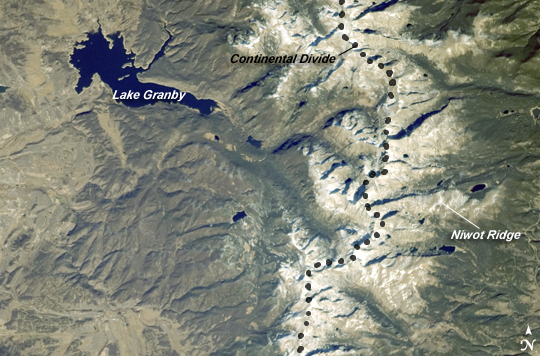 |
| Great Divide, Rocky Mountains, Colorado This astronaut photograph highlights a portion of the Great Divide in the Rocky Mountains approximately 31 kilometers due west of Boulder, Colorado. The Great Divide is one of four continental divides recognized by geographers and hydrologists in North America--the others being the Northern, Eastern, and Saint Lawrence Seaway Divides--but it is still generally (and erroneously) known as the Continental Divide. The Great Divide is a hydrologic boundary defined by the ultimate destination of precipitation; rainfall on the western side of the Divide flows to the Pacific Ocean, while rainfall on the eastern side flows to the Gulf of Mexico. It is easy to visualize such a boundary traced along the high ridges of the Rocky Mountains (dashed line), but in regions of less obvious topography, more detailed study of the local geomorphology and hydrology are required to map the location of the Divide. This portion of the Rocky Mountains also hosts the Niwot Ridge Long Term Ecological Research (LTER) Site. Part of the National Science Foundation's LTER program, the Niwot Ridge site is used for studies of climate interactions with tundra and alpine ecosystems. Niwot Ridge is visible in this image as a large eastward spur off the central spine of the mountains (center right). The entire Niwot LTER site is located at elevations higher than 3000 meters, and it includes an active cirque glacier and glacial landforms, tarns (glacial lakes), and permafrost. Lake Granby, located to the west of the Great Divide, is a reservoir on the Colorado River. It is the second-largest manmade body of water in the state of Colorado. Storage of water began in 1949. Today, the lake is popular location for fishing, boating, and camping. |
| Images: | All Available Images Low-Resolution 267k |
|
| Mission: | ISS018 |
|
| Roll - Frame: | E - 5660 |
|
| Geographical Name: | USA-COLORADO |
|
| Features: | LAKE GRANBY,TABERNASH,NIWOT RIDGE,ROCKY MOUNTAINS |
|
| Center Lat x Lon: | 40.0N x 105.7W |
|
| Film Exposure: | N=Normal exposure, U=Under exposed, O=Over exposed, F=out of Focus |
|
| Percentage of Cloud Cover-CLDP: | 10 |
|
| Camera:: | N2 |
|
| Camera Tilt: | 18 | LO=Low Oblique, HO=High Oblique, NV=Near Vertical |
| Camera Focal Length: | 180 |
|
| Nadir to Photo Center Direction: | N | The direction from the nadir to the center point, N=North, S=South, E=East, W=West |
| Stereo?: | Y=Yes there is an adjacent picture of the same area, N=No there isn't |
|
| Orbit Number: | 954 |
|
| Date: | 20081028 | YYYYMMDD |
| Time: | 172040 | GMT HHMMSS |
| Nadir Lat: | 39.0N |
Latitude of suborbital point of spacecraft |
| Nadir Lon: | 105.4W |
Longitude of suborbital point of spacecraft |
| Sun Azimuth: | 155 | Clockwise angle in degrees from north to the sun measured at the nadir point |
| Space Craft Altitude: | 188 | nautical miles |
| Sun Elevation: | 34 | Angle in degrees between the horizon and the sun, measured at the nadir point |
| Land Views: | |
|
| Water Views: | LAKE, RESERVOIR |
|
| Atmosphere Views: | |
|
| Man Made Views: | |
|
| City Views: | |
|
Photo is not associated with any sequences | ||
| NASA Home Page |
JSC Home Page |
JSC Digital Image Collection |
Earth Science & Remote Sensing |
|
This service is provided by the International Space Station program and the JSC Earth Science & Remote Sensing Unit, ARES Division, Exploration Integration Science Directorate.

|