Geographic Region: NAMIBIA
Feature: FLOODED ETOSHA PAN, EKUMA R. FLOODS
|
Geographic Region: NAMIBIA Feature: FLOODED ETOSHA PAN, EKUMA R. FLOODS |
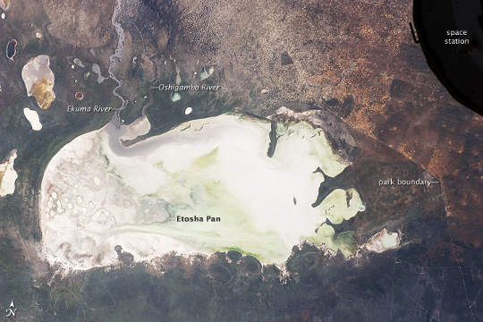 |
| Etosha Pan, Namibia This International Space Station image from March 26, 2009, shows Namibia's Etosha Pan, which is a large, dry lake about 130 kilometers long. The lake dominates Namibia's Etosha National Park (the sharp edge of the park fence can be seen at image right). Small, related dry lake beds appear as bright shapes at top left, and a portion of the International Space Station appears at image top right. The pan is the low point in a major inland basin in northern Namibia. During major flood events, such as those experienced in the last nine months, rivers from Angola (the Namibia-Angola boundary lies just outside the top of the image) deliver large quantities of water to the pan. In this image, flood water in the Oshigambo River, resulting from recent heavy rains in Angola, appears as a gray stream entering the northwest corner of the pan (image top left). The floodwater becomes a thin sheet on the vast salt flat of the pan floor. Algae blooms in the warm water have produced a light green tinge. This view shows the pan as it appeared almost ten years ago. Another astronaut image shows the Oshigambo River in flood in 2006. Reports on the ground combined with satellite imagery acquired after this astronaut photograph indicate that the plains north of the pan are now flooded, and considerable damage to homesteads, crops, and roads has occurred. More than 340,000 people have been affected in northern Namibia and about 250,000 in southern Angola. |
| Images: | All Available Images Low-Resolution 255k |
|
| Mission: | ISS018 |
|
| Roll - Frame: | E - 43947 |
|
| Geographical Name: | NAMIBIA |
|
| Features: | FLOODED ETOSHA PAN, EKUMA R. FLOODS |
|
| Center Lat x Lon: | 18.7S x 16.5E |
|
| Film Exposure: | N=Normal exposure, U=Under exposed, O=Over exposed, F=out of Focus |
|
| Percentage of Cloud Cover-CLDP: | 10 |
|
| Camera:: | N2 |
|
| Camera Tilt: | 4 | LO=Low Oblique, HO=High Oblique, NV=Near Vertical |
| Camera Focal Length: | 50 |
|
| Nadir to Photo Center Direction: | E | The direction from the nadir to the center point, N=North, S=South, E=East, W=West |
| Stereo?: | Y=Yes there is an adjacent picture of the same area, N=No there isn't |
|
| Orbit Number: | 3292 |
|
| Date: | 20090326 | YYYYMMDD |
| Time: | 102126 | GMT HHMMSS |
| Nadir Lat: | 18.6S |
Latitude of suborbital point of spacecraft |
| Nadir Lon: | 16.3E |
Longitude of suborbital point of spacecraft |
| Sun Azimuth: | 26 | Clockwise angle in degrees from north to the sun measured at the nadir point |
| Space Craft Altitude: | 196 | nautical miles |
| Sun Elevation: | 67 | Angle in degrees between the horizon and the sun, measured at the nadir point |
| Land Views: | BASIN |
|
| Water Views: | LAKE, RIVER |
|
| Atmosphere Views: | |
|
| Man Made Views: | |
|
| City Views: | |
|
Photo is not associated with any sequences | ||
| NASA Home Page |
JSC Home Page |
JSC Digital Image Collection |
Earth Science & Remote Sensing |
|
This service is provided by the International Space Station program and the JSC Earth Science & Remote Sensing Unit, ARES Division, Exploration Integration Science Directorate.

|