Geographic Region: ANTARCTICA
Feature: S. W. AREA OF HEARD I., MAWSON PEAK, FREMANTLE PEAK
|
Geographic Region: ANTARCTICA Feature: S. W. AREA OF HEARD I., MAWSON PEAK, FREMANTLE PEAK |
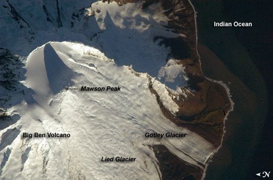 |
| Mawson Peak, Heard Island Heard Island is located in the southern Indian Ocean, approximately 1,550 kilometers (963 miles) north of Antarctica. The island is a visible part of the Kerguelen Plateau, a submerged feature on the seafloor. The plateau was formed when large amounts of volcanic rock erupted over a geologically short time period. (When large amounts of volcanic rock erupt beneath the ocean from processes other than seafloor spreading, geologists refer to them as large igneous provinces.) Most of Heard Island is formed from volcanic rocks associated with the Big Ben stratovolcano. The northeastern slopes of the volcano are visible in shadow at the lower right of this detailed astronaut photograph. Recent volcanic activity at Heard Island has occurred at 2,745-meter (9,006-foot) Mawson Peak, which sits within a breached caldera on the southwestern side of the Big Ben Volcano. Calderas form when a magma chamber beneath a volcano empties and collapses. The shadow cast by Mawson Peak points directly to the crescent-shaped caldera rim. Detailed geologic study of Big Ben Volcano is complicated by the presence of several glaciers, including Gotley and Lied Glaciers on the southwestern slopes. This image, taken during Southern Hemisphere summer, also reveals non-glaciated volcanic rock (light to dark brown) on either side of Gotley Glacier. |
| Images: | All Available Images Low-Resolution 228k |
|
| Mission: | ISS018 |
|
| Roll - Frame: | E - 38182 |
|
| Geographical Name: | ANTARCTICA |
|
| Features: | S. W. AREA OF HEARD I., MAWSON PEAK, FREMANTLE PEAK |
|
| Center Lat x Lon: | 53.1S x 73.5E |
|
| Film Exposure: | N=Normal exposure, U=Under exposed, O=Over exposed, F=out of Focus |
|
| Percentage of Cloud Cover-CLDP: | 10 |
|
| Camera:: | N2 |
|
| Camera Tilt: | 36 | LO=Low Oblique, HO=High Oblique, NV=Near Vertical |
| Camera Focal Length: | 800 |
|
| Nadir to Photo Center Direction: | SE | The direction from the nadir to the center point, N=North, S=South, E=East, W=West |
| Stereo?: | Y=Yes there is an adjacent picture of the same area, N=No there isn't |
|
| Orbit Number: | 2885 |
|
| Date: | 20090228 | YYYYMMDD |
| Time: | 125441 | GMT HHMMSS |
| Nadir Lat: | 51.3S |
Latitude of suborbital point of spacecraft |
| Nadir Lon: | 71.9E |
Longitude of suborbital point of spacecraft |
| Sun Azimuth: | 271 | Clockwise angle in degrees from north to the sun measured at the nadir point |
| Space Craft Altitude: | 197 | nautical miles |
| Sun Elevation: | 11 | Angle in degrees between the horizon and the sun, measured at the nadir point |
| Land Views: | CALDERA, GLACIER, ISLAND, PLATEAU, VOLCANO |
|
| Water Views: | OCEAN |
|
| Atmosphere Views: | |
|
| Man Made Views: | |
|
| City Views: | |
|
Photo is not associated with any sequences | ||
| NASA Home Page |
JSC Home Page |
JSC Digital Image Collection |
Earth Science & Remote Sensing |
|
This service is provided by the International Space Station program and the JSC Earth Science & Remote Sensing Unit, ARES Division, Exploration Integration Science Directorate.

|