
Geographic Region: MEXICO
Feature: POPOCATEPETL VOLCANO,SUMMIT CRATER
|
Geographic Region: MEXICO Feature: POPOCATEPETL VOLCANO,SUMMIT CRATER |
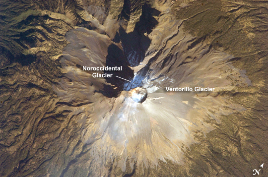 |
| Summit of Popocatepetl Volcano, Mexico Volcan Popocatepetl, a large stratovolcano located approximately 70 kilometers southeast of Mexico City, is considered by many volcanologists to be "the planet's riskiest volcano." The volcano warrants this distinction because of how close it is to one of the most densely populated megacities on Earth: near 23 million people lived in Mexico City in 2009. The variety of potential volcanic hazards at Popocatepetl is also considerable, including explosive eruptions of ash, pyroclastic flows (hot, fluid avalanches of rock fragments and gas), and debris avalanches. This detailed astronaut photograph of the summit crater of Popocatepetl (image center) also highlights Ventorillo and Noroccidental Glaciers. Together with the ice on nearby Iztaccihuatl Volcano and Pico de Orizaba (Mexico's highest peak and the highest volcano in North America), Popocatepetl's glaciers are the only mountain glaciers in tropical North America. The glaciers create yet another volcanic hazard: dangerous mudflows, or lahars, if the ice were to melt during an eruption. At the time this image was taken, steam and ash plumes were observed at the volcano. A faint white steam plume is visible against gray ash deposits on the eastern and southern flanks of the volcano. |
| Images: | All Available Images Low-Resolution 296k |
|
| Mission: | ISS018 |
|
| Roll - Frame: | E - 28898 |
|
| Geographical Name: | MEXICO |
|
| Features: | POPOCATEPETL VOLCANO,SUMMIT CRATER |
|
| Center Lat x Lon: | 19.0N x 98.6W |
|
| Film Exposure: | N=Normal exposure, U=Under exposed, O=Over exposed, F=out of Focus |
|
| Percentage of Cloud Cover-CLDP: | 10 |
|
| Camera:: | N2 |
|
| Camera Tilt: | 22 | LO=Low Oblique, HO=High Oblique, NV=Near Vertical |
| Camera Focal Length: | 800 |
|
| Nadir to Photo Center Direction: | SW | The direction from the nadir to the center point, N=North, S=South, E=East, W=West |
| Stereo?: | Y=Yes there is an adjacent picture of the same area, N=No there isn't |
|
| Orbit Number: | 2557 |
|
| Date: | 20090207 | YYYYMMDD |
| Time: | 150524 | GMT HHMMSS |
| Nadir Lat: | 19.7N |
Latitude of suborbital point of spacecraft |
| Nadir Lon: | 97.5W |
Longitude of suborbital point of spacecraft |
| Sun Azimuth: | 119 | Clockwise angle in degrees from north to the sun measured at the nadir point |
| Space Craft Altitude: | 189 | nautical miles |
| Sun Elevation: | 26 | Angle in degrees between the horizon and the sun, measured at the nadir point |
| Land Views: | CRATER, MOUNTAIN, VOLCANO |
|
| Water Views: | ICE |
|
| Atmosphere Views: | PLUME |
|
| Man Made Views: | |
|
| City Views: | |
|
Photo is not associated with any sequences | ||
| NASA Home Page |
JSC Home Page |
JSC Digital Image Collection |
Earth Science & Remote Sensing |
|
This service is provided by the International Space Station program and the JSC Earth Science & Remote Sensing Unit, ARES Division, Exploration Integration Science Directorate.

|