Geographic Region: LIBYA
Feature: MURZUQ LINEAR AND STAR DUNES
|
Geographic Region: LIBYA Feature: MURZUQ LINEAR AND STAR DUNES |
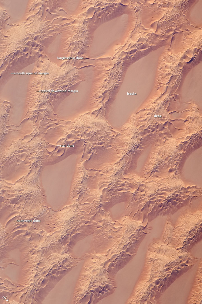 |
| Sand Dunes, Marzuq Sand Sea, Southwest Libya This detailed astronaut photograph, taken from low earth orbit, shows classic large and small sand masses of the central Sahara Desert, where wind is a more powerful land-shaping agent than water. "Draa" dunes (from the Arabic for "arm") are very large masses of sand, and they appear here as the broad network of yellow-orange sand masses, with smooth-floored, almost sand-free basins between them. These sand masses lie in the western part of Libya's vast Marzuq Sand Sea (centered at 24.5 degrees north, 12 degrees east). Geologists think that the draa of the Marzuq were probably formed by winds different from the prevailing north-northeast winds of today. Numerous smaller dunes have developed on the backs of the draa. Three distinct dune types are visible: longitudinal dunes, which are more or less parallel with the north winds; transverse dunes, which are usually more curved and formed at right angles to the wind; and star dunes, in which several linear arms converge towards a single peak. The upwind sides of the sand masses appear smoother than the downwind side. Wind is moving sand grains almost all the time. This means that the draa and the dunes are all moving as sand is added on the upwind side and blown off the downwind side. Small sand masses move much faster than large sand masses. The draa are almost stationary, but the smaller dunes move relatively quickly across their backs. When the smaller dunes reach the downwind side of the draa, they are obliterated; their sand is blown across the basins as individual grains. |
| Images: | All Available Images Low-Resolution 769k |
|
| Mission: | ISS018 |
|
| Roll - Frame: | E - 14770 |
|
| Geographical Name: | LIBYA |
|
| Features: | MURZUQ LINEAR AND STAR DUNES |
|
| Center Lat x Lon: | 24.5N x 12.1E |
|
| Film Exposure: | N=Normal exposure, U=Under exposed, O=Over exposed, F=out of Focus |
|
| Percentage of Cloud Cover-CLDP: | 10 |
|
| Camera:: | N2 |
|
| Camera Tilt: | 20 | LO=Low Oblique, HO=High Oblique, NV=Near Vertical |
| Camera Focal Length: | 400 |
|
| Nadir to Photo Center Direction: | NW | The direction from the nadir to the center point, N=North, S=South, E=East, W=West |
| Stereo?: | Y=Yes there is an adjacent picture of the same area, N=No there isn't |
|
| Orbit Number: | 1786 |
|
| Date: | 20081220 | YYYYMMDD |
| Time: | 131441 | GMT HHMMSS |
| Nadir Lat: | 23.7N |
Latitude of suborbital point of spacecraft |
| Nadir Lon: | 12.9E |
Longitude of suborbital point of spacecraft |
| Sun Azimuth: | 216 | Clockwise angle in degrees from north to the sun measured at the nadir point |
| Space Craft Altitude: | 188 | nautical miles |
| Sun Elevation: | 34 | Angle in degrees between the horizon and the sun, measured at the nadir point |
| Land Views: | DUNE |
|
| Water Views: | |
|
| Atmosphere Views: | |
|
| Man Made Views: | |
|
| City Views: | |
|
Photo is not associated with any sequences | ||
| NASA Home Page |
JSC Home Page |
JSC Digital Image Collection |
Earth Science & Remote Sensing |
|
This service is provided by the International Space Station program and the JSC Earth Science & Remote Sensing Unit, ARES Division, Exploration Integration Science Directorate.

|