
Geographic Region: USA-COLORADO
Feature: RAVEN RIDGE,MORMON GAP
|
Geographic Region: USA-COLORADO Feature: RAVEN RIDGE,MORMON GAP |
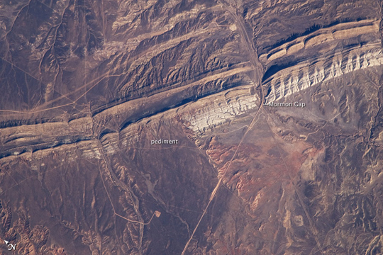 |
| Raven Ridge, Colorado An important way to unravel the Earth's history is to find and study old rocks that have been turned up and exposed on the surface through the Earth's tectonic activity. At Raven Ridge (image center, left to right), which extends across the Colorado-Utah border, geologists can walk across successive layers of rock deposited approximately 54-50 million years ago during the Eocene Epoch--approximately 10-15 million years after the dinosaurs went extinct. The sedimentary layers at Raven Ridge were originally deposited as flat-lying beds in an ancient lake known as Paleolake Uinta, and later they were tilted by tectonic forces. The tilted beds are visible in this astronaut photograph as hard, erosion-resistant ridges of tan, buff, and white rocks (freshwater limestones), with less resistant layers (mudstones and shales) forming valleys between ridges. A prominent topographic break in the ridgeline, Mormon Gap, provides road access across the ridge. To the northwest of the gap, dark brown alluvial deposits (sand and gravel carried by moving water) extend southward from the crest of the ridge. These deposits likely cover a pediment--a flat, sloping surface of eroded bedrock that extends outward from a mountain front. The rocks and fossils at Raven Ridge indicate that during the time when they were created, the area was covered in tropical forests that were filled with the early ancestors of modern primates, horses, and deer (among other animals). |
| Images: | All Available Images Low-Resolution 239k |
|
| Mission: | ISS018 |
|
| Roll - Frame: | E - 11127 |
|
| Geographical Name: | USA-COLORADO |
|
| Features: | RAVEN RIDGE,MORMON GAP |
|
| Center Lat x Lon: | 40.1N x 109W |
|
| Film Exposure: | N=Normal exposure, U=Under exposed, O=Over exposed, F=out of Focus |
|
| Percentage of Cloud Cover-CLDP: | 10 |
|
| Camera:: | N2 |
|
| Camera Tilt: | 22 | LO=Low Oblique, HO=High Oblique, NV=Near Vertical |
| Camera Focal Length: | 800 |
|
| Nadir to Photo Center Direction: | S | The direction from the nadir to the center point, N=North, S=South, E=East, W=West |
| Stereo?: | Y=Yes there is an adjacent picture of the same area, N=No there isn't |
|
| Orbit Number: | 1569 |
|
| Date: | 20081206 | YYYYMMDD |
| Time: | 191533 | GMT HHMMSS |
| Nadir Lat: | 41.3N |
Latitude of suborbital point of spacecraft |
| Nadir Lon: | 109.3W |
Longitude of suborbital point of spacecraft |
| Sun Azimuth: | 182 | Clockwise angle in degrees from north to the sun measured at the nadir point |
| Space Craft Altitude: | 186 | nautical miles |
| Sun Elevation: | 26 | Angle in degrees between the horizon and the sun, measured at the nadir point |
| Land Views: | VALLEY |
|
| Water Views: | |
|
| Atmosphere Views: | |
|
| Man Made Views: | |
|
| City Views: | |
|
Photo is not associated with any sequences | ||
| NASA Home Page |
JSC Home Page |
JSC Digital Image Collection |
Earth Science & Remote Sensing |
|
This service is provided by the International Space Station program and the JSC Earth Science & Remote Sensing Unit, ARES Division, Exploration Integration Science Directorate.

|