
Geographic Region: ITALY
Feature: ISCHIA ISLAND,PROCIDA ISLAND
|
Geographic Region: ITALY Feature: ISCHIA ISLAND,PROCIDA ISLAND |
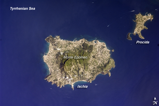 |
| Island of Ischia, Italy The island of Ischia is approximately 30 kilometers southwest of Naples, Italy, in the western Bay of Naples (part of the Tyrrenhian Sea). While the island's rocks are volcanic in origin, much of the island's geology and current topography is characterized by blocks of uplifted rock (horst) and sunken areas (grabens) between weak spots or cracks in Earth's crust (faults). For example, the highest point on the island of Ischia is Monte Epomeo (789 meters). The mountain is not a volcanic cone, but rather is composed of erupted materials that were later uplifted by faulting. The green slopes of Monte Epomeo are enclosed by urban development (light grey speckled areas) that rings the island. The last volcanic activity on Ischia took place in 1302. The neighboring island of Procida (top right) was formed from the same magma sources as Ischia, and likely shared the same volcanic "plumbing system." Today, Ischia is a popular tourist destination due to its hot springs, hot mud baths, and the hiking opportunities afforded by Monte Epomeo. Several boat wakes are visible around both islands in this astronaut photograph. |
| Images: | All Available Images Low-Resolution 165k |
|
| Mission: | ISS017 |
|
| Roll - Frame: | E - 9734 |
|
| Geographical Name: | ITALY |
|
| Features: | ISCHIA ISLAND,PROCIDA ISLAND |
|
| Center Lat x Lon: | 40.7N x 13.9E |
|
| Film Exposure: | N=Normal exposure, U=Under exposed, O=Over exposed, F=out of Focus |
|
| Percentage of Cloud Cover-CLDP: | 10 |
|
| Camera:: | N2 |
|
| Camera Tilt: | 2 | LO=Low Oblique, HO=High Oblique, NV=Near Vertical |
| Camera Focal Length: | 400 |
|
| Nadir to Photo Center Direction: | E | The direction from the nadir to the center point, N=North, S=South, E=East, W=West |
| Stereo?: | Y=Yes there is an adjacent picture of the same area, N=No there isn't |
|
| Orbit Number: | 2902 |
|
| Date: | 20080620 | YYYYMMDD |
| Time: | 080043 | GMT HHMMSS |
| Nadir Lat: | 40.7N |
Latitude of suborbital point of spacecraft |
| Nadir Lon: | 13.8E |
Longitude of suborbital point of spacecraft |
| Sun Azimuth: | 99 | Clockwise angle in degrees from north to the sun measured at the nadir point |
| Space Craft Altitude: | 186 | nautical miles |
| Sun Elevation: | 48 | Angle in degrees between the horizon and the sun, measured at the nadir point |
| Land Views: | ISLAND, MOUNTAIN |
|
| Water Views: | BAY, SEA |
|
| Atmosphere Views: | |
|
| Man Made Views: | |
|
| City Views: | |
|
Photo is not associated with any sequences | ||
| NASA Home Page |
JSC Home Page |
JSC Digital Image Collection |
Earth Science & Remote Sensing |
|
This service is provided by the International Space Station program and the JSC Earth Science & Remote Sensing Unit, ARES Division, Exploration Integration Science Directorate.

|