
Geographic Region: EGYPT
Feature: PYRAMIDS, DAHSHUR, NILE R. V.
|
Geographic Region: EGYPT Feature: PYRAMIDS, DAHSHUR, NILE R. V. |
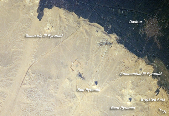 |
| Pyramids of Dashur, Egypt While the pyramids of Giza are perhaps the most famous, there are several other ancient Egyptian royal necropolis ("city of the dead") sites situated along the Nile River and its delta. One of these sites is near the village of Dashur, illustrated in this astronaut photograph. The gray-brown built area of Dashur is surrounded by green agricultural land of the Nile Delta, which forms a distinct boundary with the tan desert to the west. It is in the desert that the monuments of the ancient rulers of Egypt are found. Several monuments are visible in this image, including the large Red and Bent Pyramids built by Snofru, first king of the Fourth Dynasty, which lasted from 2575-2465 BC. Other visible monuments include the pyramid complexes of Amenemhat III and Sesostris III, both kings of the Twelfth Dynasty (1991-1783 BC). Both of these complexes are poorly preserved, due to both the unstable ground conditions and the dismantling of the limestone blocks forming the outer pyramid casings during later historical periods. The Bent Pyramid (image upper right) is so called because the slope of the outer face was lessened halfway through construction, leading to a distinctive "bent" profile. Scholars have offered different explanations for why this was done: perhaps to decrease the mass of the pyramid to prevent its collapse or to reduce the work necessary to complete it. The Red Pyramid to the north (image center) was built after the Bent Pyramid, and is named for the coloration of the building stone at the structure's core. Compare the shadows of the Red and Bent pyramids in the image to see the different profiles of the structures (easier to see in the large image.) An irregular, dark feature to the southeast of the Bent Pyramid is not a shadow cast by a monument; it is an irrigation area extending into the desert. |
| Images: | All Available Images Low-Resolution 270k |
|
| Mission: | ISS017 |
|
| Roll - Frame: | E - 8285 |
|
| Geographical Name: | EGYPT |
|
| Features: | PYRAMIDS, DAHSHUR, NILE R. V. |
|
| Center Lat x Lon: | 29.8N x 31.2E |
|
| Film Exposure: | N=Normal exposure, U=Under exposed, O=Over exposed, F=out of Focus |
|
| Percentage of Cloud Cover-CLDP: | 10 |
|
| Camera:: | N2 |
|
| Camera Tilt: | 40 | LO=Low Oblique, HO=High Oblique, NV=Near Vertical |
| Camera Focal Length: | 800 |
|
| Nadir to Photo Center Direction: | SE | The direction from the nadir to the center point, N=North, S=South, E=East, W=West |
| Stereo?: | Y=Yes there is an adjacent picture of the same area, N=No there isn't |
|
| Orbit Number: | 2575 |
|
| Date: | 20080530 | YYYYMMDD |
| Time: | 143208 | GMT HHMMSS |
| Nadir Lat: | 32.0N |
Latitude of suborbital point of spacecraft |
| Nadir Lon: | 30.0E |
Longitude of suborbital point of spacecraft |
| Sun Azimuth: | 279 | Clockwise angle in degrees from north to the sun measured at the nadir point |
| Space Craft Altitude: | 182 | nautical miles |
| Sun Elevation: | 29 | Angle in degrees between the horizon and the sun, measured at the nadir point |
| Land Views: | DESERT |
|
| Water Views: | RIVER, DELTA |
|
| Atmosphere Views: | |
|
| Man Made Views: | PYRAMID |
|
| City Views: | |
|
Photo is not associated with any sequences | ||
| NASA Home Page |
JSC Home Page |
JSC Digital Image Collection |
Earth Science & Remote Sensing |
|
This service is provided by the International Space Station program and the JSC Earth Science & Remote Sensing Unit, ARES Division, Exploration Integration Science Directorate.

|