
Geographic Region: PERU
Feature: CERRO YERUPAJA, GLACIER, LAKES
|
Geographic Region: PERU Feature: CERRO YERUPAJA, GLACIER, LAKES |
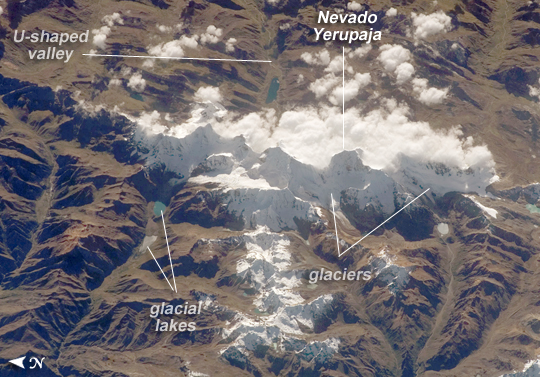 |
| Cordillera Huayhuash, Peruvian Andes This astronaut photograph was taken looking east as the International Space Station was flying about 100 kilometers (about 62 miles) off the Peruvian coast and shows Cordillera Huayhuash (pronounced "Why-wash"). Clouds are banked up on the east side, snow covers all higher slopes and mountain peaks, and glaciers occupy lower slopes. This prominent but short mountain range (25 kilometers in length) boasts twenty peaks of remarkable steepness and ridge sharpness. Although only 100 kilometers from the coastline, six of the peaks reach above 6,000 meters (more than 19,500 feet); the highest is Nevado Yerupaja, Peru's second highest peak, variously estimated as 6,617 and 6,635 meters high. Widely considered the most spectacular peak in South America, Yerupaja is so steep that it has seldom been climbed. The best climbing approach is from the southwest, the face seen in this view. Yerupaja is locally known as El Carnicero ("The Butcher") because of its blade-like ridges, typical of mountains that have been heavily eroded by glacial ice. Other features created by the erosive effect of flowing ice are small glacial lakes, which often vary in color due to different amounts of fine mud being fed into them by meltwater from under the glaciers. During the ice ages, the glaciers advanced many kilometers outward from the cordillera, occupying all the surrounding valley floors (all of which lie above 3,000 meters), producing U-shape valleys. |
| Images: | All Available Images Low-Resolution 296k |
|
| Mission: | ISS017 |
|
| Roll - Frame: | E - 7322 |
|
| Geographical Name: | PERU |
|
| Features: | CERRO YERUPAJA, GLACIER, LAKES |
|
| Center Lat x Lon: | 10.3S x 76.9W |
|
| Film Exposure: | N=Normal exposure, U=Under exposed, O=Over exposed, F=out of Focus |
|
| Percentage of Cloud Cover-CLDP: | 10 |
|
| Camera:: | E4 |
|
| Camera Tilt: | 37 | LO=Low Oblique, HO=High Oblique, NV=Near Vertical |
| Camera Focal Length: | 400 |
|
| Nadir to Photo Center Direction: | E | The direction from the nadir to the center point, N=North, S=South, E=East, W=West |
| Stereo?: | Y=Yes there is an adjacent picture of the same area, N=No there isn't |
|
| Orbit Number: | 2369 |
|
| Date: | 20080517 | YYYYMMDD |
| Time: | 134616 | GMT HHMMSS |
| Nadir Lat: | 11.2S |
Latitude of suborbital point of spacecraft |
| Nadir Lon: | 79W |
Longitude of suborbital point of spacecraft |
| Sun Azimuth: | 59 | Clockwise angle in degrees from north to the sun measured at the nadir point |
| Space Craft Altitude: | 183 | nautical miles |
| Sun Elevation: | 31 | Angle in degrees between the horizon and the sun, measured at the nadir point |
| Land Views: | MOUNTAIN, RANGE, VALLEY |
|
| Water Views: | ICE |
|
| Atmosphere Views: | |
|
| Man Made Views: | |
|
| City Views: | |
|
Photo is not associated with any sequences | ||
| NASA Home Page |
JSC Home Page |
JSC Digital Image Collection |
Earth Science & Remote Sensing |
|
This service is provided by the International Space Station program and the JSC Earth Science & Remote Sensing Unit, ARES Division, Exploration Integration Science Directorate.

|