
Geographic Region: USA-ARIZONA
Feature: PARIA RIVER, PARIA PLATEAU
|
Geographic Region: USA-ARIZONA Feature: PARIA RIVER, PARIA PLATEAU |
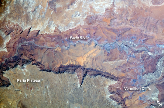 |
| Vermilion Cliffs and Paria River, Arizona The largest tributary of the Colorado River between Lake Powell and the Grand Canyon, the Paria River flows southeast from its headwaters in southernmost Utah to join the Colorado River between Page, Arizona, and Marble Canyon. The Paria River provides spectacular scenery, and is known for the very narrow "slot" canyons that it cuts through the layered rocks of the Colorado Plateau. These canyons formed over millions of years by water erosion slicing deep into the rock layers. Exploring the river channel through the slot canyons is a popular activity for hikers and backpackers. Indeed, there is no road access to much of the river channel, and hiking in on foot is the only way to experience the slot canyons. The Paria River also exposes the red and white layers of rocks beneath the Paria Plateau that are known as the Vermilion Cliffs (image center). These rocks record the changing environmental conditions of the region during the early Mesozoic Era (248 to 65 million years ago), ranging from widespread deserts to more water-rich periods when rivers flowed across the landscape. The spectacular scenery of the Vermilion Cliffs and Paria Canyon falls within the Vermilion Cliffs National Monument. This rugged and remote landscape is also home to many species of raptors, including the California condor, and other desert fauna like bighorn sheep. |
| Images: | All Available Images Low-Resolution 258k |
|
| Mission: | ISS017 |
|
| Roll - Frame: | E - 6110 |
|
| Geographical Name: | USA-ARIZONA |
|
| Features: | PARIA RIVER, PARIA PLATEAU |
|
| Center Lat x Lon: | 36.9N x 111.6W |
|
| Film Exposure: | N=Normal exposure, U=Under exposed, O=Over exposed, F=out of Focus |
|
| Percentage of Cloud Cover-CLDP: | 0 |
|
| Camera:: | E4 |
|
| Camera Tilt: | 20 | LO=Low Oblique, HO=High Oblique, NV=Near Vertical |
| Camera Focal Length: | 800 |
|
| Nadir to Photo Center Direction: | NW | The direction from the nadir to the center point, N=North, S=South, E=East, W=West |
| Stereo?: | Y=Yes there is an adjacent picture of the same area, N=No there isn't |
|
| Orbit Number: | 2136 |
|
| Date: | 20080502 | YYYYMMDD |
| Time: | 185738 | GMT HHMMSS |
| Nadir Lat: | 36.4N |
Latitude of suborbital point of spacecraft |
| Nadir Lon: | 110.6W |
Longitude of suborbital point of spacecraft |
| Sun Azimuth: | 165 | Clockwise angle in degrees from north to the sun measured at the nadir point |
| Space Craft Altitude: | 180 | nautical miles |
| Sun Elevation: | 69 | Angle in degrees between the horizon and the sun, measured at the nadir point |
| Land Views: | DESERT, EROSION, PLATEAU |
|
| Water Views: | CHANNEL, LAKE, RIVER |
|
| Atmosphere Views: | |
|
| Man Made Views: | |
|
| City Views: | PAGE |
|
Photo is not associated with any sequences | ||
| NASA Home Page |
JSC Home Page |
JSC Digital Image Collection |
Earth Science & Remote Sensing |
|
This service is provided by the International Space Station program and the JSC Earth Science & Remote Sensing Unit, ARES Division, Exploration Integration Science Directorate.

|