
Geographic Region: USA-LOUISIANA
Feature: L. PONCHARTRAIN, SED. PLUME
|
Geographic Region: USA-LOUISIANA Feature: L. PONCHARTRAIN, SED. PLUME |
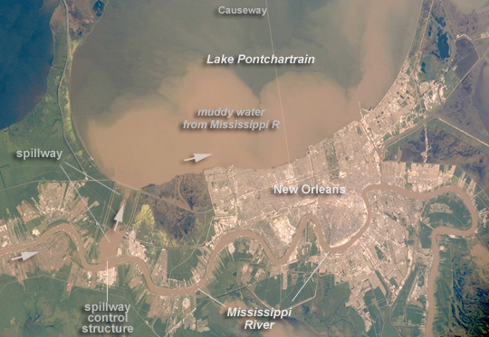 |
| Lake Pontchartrain and the Bonnet Carre Spillway, Louisiana, USA Lake Pontchartrain, a big body of water immediately north of New Orleans, occupies the upper part of this astronaut photograph, with the winding course of the muddy Mississippi River snaking across the bottom of the view (flow is east, from left to right). The city of New Orleans is sandwiched between the lake and river. Heavy rain in March and April 2008 in the Mississippi's catchment area raised water levels in the river sufficiently to make the Army Corps of Engineers take action. To reduce the volume of the river where it passes through New Orleans, the Corps opened the Bonnet Carre Spillway (lower left), a major engineering structure 18 km upriver from New Orleans. The spillway, a 1.6 km-wide gap in the developments along the Mississippi levees, is an integral part of the river and canal system that allows Mississippi river water to flow into Lake Pontchartrain. The spillway control structure itself is visible as a thin, discontinuous, white line along the river's edge in this image. The spillway has only been opened eight times since 1937. News of the opening in April 2008 was transmitted to astronauts aboard the International Space Station who managed to capture the immediate effect of muddy water flowing down the spillway and into Lake Pontchartrain, where it forms great brown lobes in the otherwise green water. These lobes moved slowly east along the New Orleans shoreline, where the line of the Lake Pontchartrain Causeway, the longest bridge in the U.S., can be seen, top right. Opening the spillway protects New Orleans in various ways. First, it reduces pressure on the levees, which famously collapsed at some points during the onslaught of Hurricane Katrina in 2005. Keeping water levels below critical high levels also helps the river channel to accommodate the discharge of water, and reduces both the speed of flow and cross currents in the river which can interfere with vessels navigating the river - or even cause collisions with levees. |
| Images: | All Available Images Low-Resolution 225k |
|
| Mission: | ISS017 |
|
| Roll - Frame: | E - 5763 |
|
| Geographical Name: | USA-LOUISIANA |
|
| Features: | L. PONCHARTRAIN, SED. PLUME |
|
| Center Lat x Lon: | 30.0N x 90W |
|
| Film Exposure: | N=Normal exposure, U=Under exposed, O=Over exposed, F=out of Focus |
|
| Percentage of Cloud Cover-CLDP: | 10 |
|
| Camera:: | E4 |
|
| Camera Tilt: | 38 | LO=Low Oblique, HO=High Oblique, NV=Near Vertical |
| Camera Focal Length: | 180 |
|
| Nadir to Photo Center Direction: | E | The direction from the nadir to the center point, N=North, S=South, E=East, W=West |
| Stereo?: | Y=Yes there is an adjacent picture of the same area, N=No there isn't |
|
| Orbit Number: | 2089 |
|
| Date: | 20080429 | YYYYMMDD |
| Time: | 192803 | GMT HHMMSS |
| Nadir Lat: | 30.7N |
Latitude of suborbital point of spacecraft |
| Nadir Lon: | 92.2W |
Longitude of suborbital point of spacecraft |
| Sun Azimuth: | 235 | Clockwise angle in degrees from north to the sun measured at the nadir point |
| Space Craft Altitude: | 180 | nautical miles |
| Sun Elevation: | 66 | Angle in degrees between the horizon and the sun, measured at the nadir point |
| Land Views: | |
|
| Water Views: | CANAL, CHANNEL, LAKE, RIVER |
|
| Atmosphere Views: | |
|
| Man Made Views: | BRIDGE |
|
| City Views: | NEW ORLEANS |
|
Photo is not associated with any sequences | ||
| NASA Home Page |
JSC Home Page |
JSC Digital Image Collection |
Earth Science & Remote Sensing |
|
This service is provided by the International Space Station program and the JSC Earth Science & Remote Sensing Unit, ARES Division, Exploration Integration Science Directorate.

|