
Geographic Region: LIBYA
Feature: ARKENU 1 AND 2 STRUCTURES
|
Geographic Region: LIBYA Feature: ARKENU 1 AND 2 STRUCTURES |
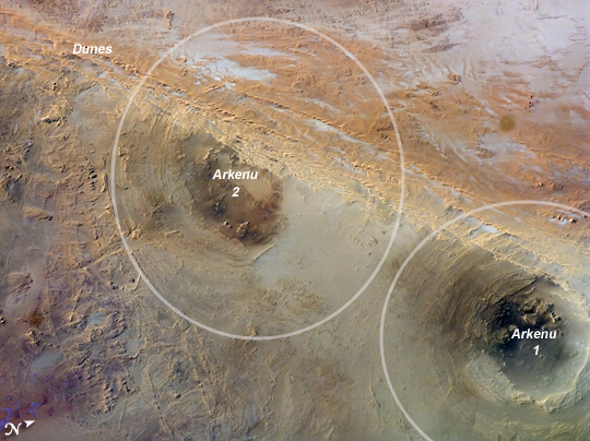 |
| Arkenu Craters 1 and 2, Libya Geologists often study features on Earth, such as impact craters, to gain insight into processes that occur on other planets. On Earth, more than 150 impact craters have been identified on the continents, but only a few of these are classified as double impact craters. One such pair, the Arkenu Craters in northern Africa, is shown in this image. Arkenu 1 and 2 are double impact structures located in eastern Libya in the Sahara Desert (22 degrees, 4 minutes North; 23 degrees, 45 minutes East). Their respective diameters are approximately 6.8 and 10.3 kilometers (4.2 and 6.4 miles). The craters are unusual in that they both exhibit concentric annular ridge structures (white circles in the image outline the position of the outermost visible ridges). In many terrestrial craters these features are highly eroded and no longer visible. While the circular structure of these features had been noted, the impact origin hypothesis was strengthened in December 2003 when a field team observed shatter cones--cone-shaped features in rocks created by the shock generated during impact. The field research team also observed large outcrops of impact breccias--a jumble of rock fragments generated at the impact site that are now cemented together into an identifiable rock layer. One theory of the craters' formation proposes they were the result of two impactors, each approximately 500 meters in diameter. The age of the impact event has been dated as having occurred less than 140 million years ago. While the presence of shatter cones and impact breccias is generally considered to be strong evidence for meteor impact, some scientists now question the interpretation of these features observed at the Arkenu structures. They suggest that the features were caused by erosive and volcanic processes. At present, both craters are being crossed by linear dunes extending northeast-southwest (image upper left to center right). The superposition of the dunes across the annular ridges indicates that they are much younger than the craters. |
| Images: | All Available Images Low-Resolution 282k |
|
| Mission: | ISS017 |
|
| Roll - Frame: | E - 20538 |
|
| Geographical Name: | LIBYA |
|
| Features: | ARKENU 1 AND 2 STRUCTURES |
|
| Center Lat x Lon: | 22.1N x 23.7E |
|
| Film Exposure: | N=Normal exposure, U=Under exposed, O=Over exposed, F=out of Focus |
|
| Percentage of Cloud Cover-CLDP: | 10 |
|
| Camera:: | N2 |
|
| Camera Tilt: | 8 | LO=Low Oblique, HO=High Oblique, NV=Near Vertical |
| Camera Focal Length: | 400 |
|
| Nadir to Photo Center Direction: | NE | The direction from the nadir to the center point, N=North, S=South, E=East, W=West |
| Stereo?: | Y=Yes there is an adjacent picture of the same area, N=No there isn't |
|
| Orbit Number: | 841 |
|
| Date: | 20081021 | YYYYMMDD |
| Time: | 130556 | GMT HHMMSS |
| Nadir Lat: | 21.8N |
Latitude of suborbital point of spacecraft |
| Nadir Lon: | 23.4E |
Longitude of suborbital point of spacecraft |
| Sun Azimuth: | 237 | Clockwise angle in degrees from north to the sun measured at the nadir point |
| Space Craft Altitude: | 189 | nautical miles |
| Sun Elevation: | 36 | Angle in degrees between the horizon and the sun, measured at the nadir point |
| Land Views: | DESERT |
|
| Water Views: | |
|
| Atmosphere Views: | |
|
| Man Made Views: | |
|
| City Views: | |
|
Photo is not associated with any sequences | ||
| NASA Home Page |
JSC Home Page |
JSC Digital Image Collection |
Earth Science & Remote Sensing |
|
This service is provided by the International Space Station program and the JSC Earth Science & Remote Sensing Unit, ARES Division, Exploration Integration Science Directorate.

|