
Geographic Region: USA-COLORADO
Feature: PUEBLO CHEMICAL DEPOT
|
Geographic Region: USA-COLORADO Feature: PUEBLO CHEMICAL DEPOT |
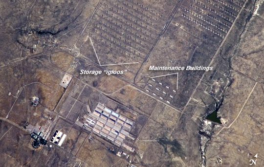 |
| Pueblo Chemical Depot, Colorado This astronaut photograph illustrates the unusual man-made landscape of the Pueblo Chemical Depot located near the city of Pueblo, Colorado. The depot was built during World War II by the U.S. Army to house and ship ammunition needed for war efforts, and this role transitioned to missile repair and maintenance during the Cold War with the Soviet Union. The current use of the depot is to house chemical munitions, but changes are underway by the U.S. Army Chemical Materials Agency to destroy these munitions and make the site environmentally safe for reuse. The stippled pattern on the landscape is due to hundreds of concrete and earth-covered storage "igloos" that form ordered rows across the site (image top). These igloos are where chemical munitions and other materials are secured. Larger, white-roofed maintenance buildings once used for munitions storage were built with separate compartments to minimize potential damage from explosions. Other features visible in this detailed image include roads (light tan lines) and rail lines (dark brown), water impoundments (black, irregular shapes), and various office and industrial buildings (rectangular shapes at image lower left.) |
| Images: | All Available Images Low-Resolution 266k |
|
| Mission: | ISS017 |
|
| Roll - Frame: | E - 18075 |
|
| Geographical Name: | USA-COLORADO |
|
| Features: | PUEBLO CHEMICAL DEPOT |
|
| Center Lat x Lon: | 38.3N x 104.3W |
|
| Film Exposure: | N=Normal exposure, U=Under exposed, O=Over exposed, F=out of Focus |
|
| Percentage of Cloud Cover-CLDP: | 10 |
|
| Camera:: | N2 |
|
| Camera Tilt: | 18 | LO=Low Oblique, HO=High Oblique, NV=Near Vertical |
| Camera Focal Length: | 800 |
|
| Nadir to Photo Center Direction: | N | The direction from the nadir to the center point, N=North, S=South, E=East, W=West |
| Stereo?: | Y=Yes there is an adjacent picture of the same area, N=No there isn't |
|
| Orbit Number: | 532 |
|
| Date: | 20081001 | YYYYMMDD |
| Time: | 211747 | GMT HHMMSS |
| Nadir Lat: | 37.3N |
Latitude of suborbital point of spacecraft |
| Nadir Lon: | 104.3W |
Longitude of suborbital point of spacecraft |
| Sun Azimuth: | 229 | Clockwise angle in degrees from north to the sun measured at the nadir point |
| Space Craft Altitude: | 189 | nautical miles |
| Sun Elevation: | 36 | Angle in degrees between the horizon and the sun, measured at the nadir point |
| Land Views: | |
|
| Water Views: | |
|
| Atmosphere Views: | |
|
| Man Made Views: | |
|
| City Views: | |
|
Photo is not associated with any sequences | ||
| NASA Home Page |
JSC Home Page |
JSC Digital Image Collection |
Earth Science & Remote Sensing |
|
This service is provided by the International Space Station program and the JSC Earth Science & Remote Sensing Unit, ARES Division, Exploration Integration Science Directorate.

|