Geographic Region: BOUVET ISLAND
Feature: CAPE VALDIVIA,SEA ICE,GLACIERS
|
Geographic Region: BOUVET ISLAND Feature: CAPE VALDIVIA,SEA ICE,GLACIERS |
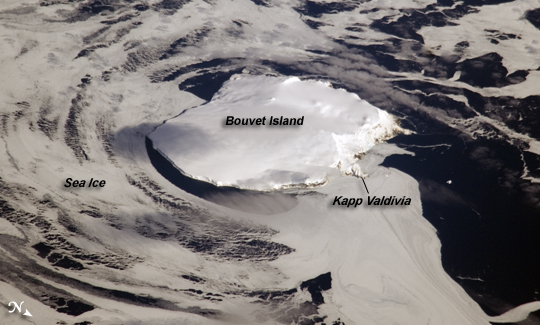 |
| Bouvet Island, South Atlantic Ocean Bouvet Island (in Norwegian, Bouvetoya) is known as the most remote island in the world; Antarctica, over 1600 kilometers (994 miles) to the south, is the nearest land mass. Located near the junction between the South American, African, and Antarctic tectonic plates, the island is mostly formed from a shield volcano--a broad, gently sloping cone formed by thin, fluid lavas--that is almost entirely covered by glaciers. The prominent Kapp (Cape) Valdivia on the northern coastline is a peninsula formed by a lava dome, a volcanic feature built by viscous lavas with a high silica content. It is only along the steep cliffs of the coastline that the underlaying dark volcanic rock is visible against the white snow and ice blanketing the island. Bouvet Island was discovered by the French Captain Lozier-Bouvet in 1739, and was subsequently visited by representatives of different nations several times during the nineteenth century. The island was annexed by the Kingdom of Norway in 1927 following a Norwegian expedition's stay on the island. Bouvet is uninhabited, and its extremely harsh environment precludes anything but short-duration stays. Nevertheless, the island supports some flora (such as lichens) and fauna (seabirds and seals). Abundant sea ice surrounds the island in this astronaut photograph. |
| Images: | All Available Images Low-Resolution 182k |
|
| Mission: | ISS017 |
|
| Roll - Frame: | E - 16161 |
|
| Geographical Name: | BOUVET ISLAND |
|
| Features: | CAPE VALDIVIA,SEA ICE,GLACIERS |
|
| Center Lat x Lon: | 54.4S x 3.4E |
|
| Film Exposure: | N=Normal exposure, U=Under exposed, O=Over exposed, F=out of Focus |
|
| Percentage of Cloud Cover-CLDP: | 10 |
|
| Camera:: | N2 |
|
| Camera Tilt: | HO | LO=Low Oblique, HO=High Oblique, NV=Near Vertical |
| Camera Focal Length: | 800 |
|
| Nadir to Photo Center Direction: | W | The direction from the nadir to the center point, N=North, S=South, E=East, W=West |
| Stereo?: | Y=Yes there is an adjacent picture of the same area, N=No there isn't |
|
| Orbit Number: | 242 |
|
| Date: | 20080913 | YYYYMMDD |
| Time: | 114721 | GMT HHMMSS |
| Nadir Lat: | 51S |
Latitude of suborbital point of spacecraft |
| Nadir Lon: | 10.3E |
Longitude of suborbital point of spacecraft |
| Sun Azimuth: | 350 | Clockwise angle in degrees from north to the sun measured at the nadir point |
| Space Craft Altitude: | 195 | nautical miles |
| Sun Elevation: | 35 | Angle in degrees between the horizon and the sun, measured at the nadir point |
| Land Views: | CAPE, ISLAND, PENINSULA, VOLCANO |
|
| Water Views: | ICE, OCEAN, SEA ICE |
|
| Atmosphere Views: | |
|
| Man Made Views: | |
|
| City Views: | |
|
Photo is not associated with any sequences | ||
| NASA Home Page |
JSC Home Page |
JSC Digital Image Collection |
Earth Science & Remote Sensing |
|
This service is provided by the International Space Station program and the JSC Earth Science & Remote Sensing Unit, ARES Division, Exploration Integration Science Directorate.

|