Geographic Region: BRAZIL
Feature: AMAZON RIVER, LAKES, R., GLINT
|
Geographic Region: BRAZIL Feature: AMAZON RIVER, LAKES, R., GLINT |
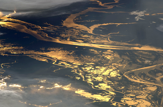 |
| Sunglint on the Amazon River, Brazil The setting sun glints off the Amazon River and numerous lakes in its floodplain in this astronaut photograph from August 19, 2008. Large areas of sunglint are common in oblique views (shot from an angle, rather than looking straight down from the spacecraft). About 150 kilometers of the sinuous Amazon is shown here; the area is about 1,000 kilometers inland from the Atlantic Ocean. Arrows show the generally eastward direction of flow of the Amazon. One of the great river's tributaries, the Uatuma River, enters on the north side of the Amazon (top center). A small side channel, or distributary, of the Madeira River (beyond the left edge of the image) enters the view from the left. Tupinambarama Island occupies the swampy wetlands between the Amazon and Madeira rivers. Sunglint images reveal great detail in surface water--in this case the marked difference between the smooth outline of the Amazon and the jagged shoreline of the Uatuma River. The jagged shoreline results from valley sides being eroded in relatively hard rocks. Because the Amazon flows in its own soft sediment, its huge water discharge smoothes its banks. The Uatuma River in this area has become a ria, a dammed valley. Sediment from the Amazon has created the dam. Another dammed valley is visible at bottom center of the scene. Although no smoke plumes from forest fires are visible in the view, two kinds of evidence show that there is smoke in the atmosphere. The coppery color of the sunglint is typically produced by smoke particles and other aerosols scattering yellow and red light. Second, a small patch of cloud (image right) casts a distinct shadow in the atmosphere. The shadow is visible because smoke particles in the surrounding sunlit parts of the atmosphere are reflecting light back to the camera. |
| Images: | All Available Images Low-Resolution 234k |
|
| Mission: | ISS017 |
|
| Roll - Frame: | E - 13856 |
|
| Geographical Name: | BRAZIL |
|
| Features: | AMAZON RIVER, LAKES, R., GLINT |
|
| Center Lat x Lon: | 2.7S x 57.6W |
|
| Film Exposure: | N=Normal exposure, U=Under exposed, O=Over exposed, F=out of Focus |
|
| Percentage of Cloud Cover-CLDP: | 25 |
|
| Camera:: | N2 |
|
| Camera Tilt: | HO | LO=Low Oblique, HO=High Oblique, NV=Near Vertical |
| Camera Focal Length: | 400 |
|
| Nadir to Photo Center Direction: | W | The direction from the nadir to the center point, N=North, S=South, E=East, W=West |
| Stereo?: | Y=Yes there is an adjacent picture of the same area, N=No there isn't |
|
| Orbit Number: | 3855 |
|
| Date: | 20080819 | YYYYMMDD |
| Time: | 205358 | GMT HHMMSS |
| Nadir Lat: | 4.9S |
Latitude of suborbital point of spacecraft |
| Nadir Lon: | 48.8W |
Longitude of suborbital point of spacecraft |
| Sun Azimuth: | 283 | Clockwise angle in degrees from north to the sun measured at the nadir point |
| Space Craft Altitude: | 196 | nautical miles |
| Sun Elevation: | 5 | Angle in degrees between the horizon and the sun, measured at the nadir point |
| Land Views: | FOREST, ISLAND, VALLEY |
|
| Water Views: | CHANNEL, RIVER, SEDIMENT, SUNGLINT |
|
| Atmosphere Views: | SMOKE |
|
| Man Made Views: | DAM |
|
| City Views: | |
|
Photo is not associated with any sequences | ||
| NASA Home Page |
JSC Home Page |
JSC Digital Image Collection |
Earth Science & Remote Sensing |
|
This service is provided by the International Space Station program and the JSC Earth Science & Remote Sensing Unit, ARES Division, Exploration Integration Science Directorate.

|