
Geographic Region: TUNISIA
Feature: TUNIS METRO AREA,LAKE OF TUNIS
|
Geographic Region: TUNISIA Feature: TUNIS METRO AREA,LAKE OF TUNIS |
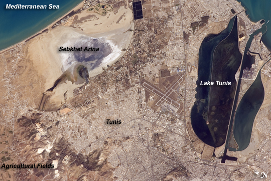 |
| Tunis, Tunisia The city of Tunis, capital of Tunisia, is located along the Mediterranean coast of northern Africa. Sharing much of its history with famous Carthage to the north, Tunis was also destroyed by the Roman Empire in approximately 146 BC. Tunis, however, was rebuilt by the Romans and became an important agricultural center. Modern Tunis serves as the administrative center for the whole of Tunisia, and as a commercial hub in the northern part of the country. The urban area of Tunis is located on a flat coastal plain, and is distinguished in this astronaut photograph from the surrounding desert by the pattern of grey and tan buildings and the dark street grid. The city is bordered by an evaporating saline lake to the northeast known as Sebkhet Arina (upper left). Evaporite minerals such as halite (sodium chloride, or table salt) and gypsum produce the white deposits. They surround the darker lake center, where there is more moisture. The western urban-rural fringe is defined by a range of low hills (lower left). On the western side of these hills, dark green agricultural fields are visible. To the southeast of the city is Lake Tunis, a lagoon that people have significantly altered from its natural state. For example, it is completely closed off from the Mediterranean Sea except for two channels, and has been since Roman times. The general lack of water circulation and input of nutrients from wastewater have altered the ecosystem, allowing reef-forming marine worms to become established; the reefs further stifle water circulation. The wastewater also causes eutrophication (overly fertile waters that trigger algae overgrowth) and occasional fish kills. |
| Images: | All Available Images Low-Resolution 290k |
|
| Mission: | ISS017 |
|
| Roll - Frame: | E - 13769 |
|
| Geographical Name: | TUNISIA |
|
| Features: | TUNIS METRO AREA,LAKE OF TUNIS |
|
| Center Lat x Lon: | 36.9N x 10.2E |
|
| Film Exposure: | N=Normal exposure, U=Under exposed, O=Over exposed, F=out of Focus |
|
| Percentage of Cloud Cover-CLDP: | 10 |
|
| Camera:: | N2 |
|
| Camera Tilt: | 23 | LO=Low Oblique, HO=High Oblique, NV=Near Vertical |
| Camera Focal Length: | 400 |
|
| Nadir to Photo Center Direction: | NE | The direction from the nadir to the center point, N=North, S=South, E=East, W=West |
| Stereo?: | Y=Yes there is an adjacent picture of the same area, N=No there isn't |
|
| Orbit Number: | 3851 |
|
| Date: | 20080819 | YYYYMMDD |
| Time: | 143346 | GMT HHMMSS |
| Nadir Lat: | 35.8N |
Latitude of suborbital point of spacecraft |
| Nadir Lon: | 9.4E |
Longitude of suborbital point of spacecraft |
| Sun Azimuth: | 253 | Clockwise angle in degrees from north to the sun measured at the nadir point |
| Space Craft Altitude: | 190 | nautical miles |
| Sun Elevation: | 42 | Angle in degrees between the horizon and the sun, measured at the nadir point |
| Land Views: | COAST, DESERT, PLAIN, RANGE |
|
| Water Views: | LAGOON, LAKE, SEA |
|
| Atmosphere Views: | |
|
| Man Made Views: | URBAN AREA |
|
| City Views: | TUNIS |
|
Photo is not associated with any sequences | ||
| NASA Home Page |
JSC Home Page |
JSC Digital Image Collection |
Earth Science & Remote Sensing |
|
This service is provided by the International Space Station program and the JSC Earth Science & Remote Sensing Unit, ARES Division, Exploration Integration Science Directorate.

|