Geographic Region: ALGERIA
Feature: TIFERNINE DUNE FIELD
|
Geographic Region: ALGERIA Feature: TIFERNINE DUNE FIELD |
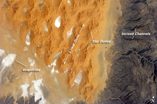 |
| Tifernine Dune Field, Algeria The Tifernine Dune Field is located at the southernmost tip of the Grand Erg Oriental, a "dune sea" that occupies a large portion of the Sahara Desert in eastern Algeria. This astronaut photograph illustrates the interface between the yellow-orange sand dunes of the field and dark brown consolidated rocks of the Tinrhert Plateau to the south and east (image right). Three distinct landforms are visible in the image, each providing information about past and present climate in the area. The oldest landform is represented by the rocks of the Tinrhert Plateau, where numerous channels incise the bedrock; these channels were eroded during a wet and cool climate period, most probably by glacial meltwater streams. As the dry and hot climate that characterizes the Sahara today became established, water ceased to flow in these channels. Winds eroded and moved large amounts of drying sediment (sand, silt, and clay), which piled up in large, linear dunes that roughly parallel the direction of the prevailing winds of the time (image center). The present climate is still hot and dry, but current wind directions are more variable. The variable winds are modifying the older, linear dunes, creating star dunes, recognizable by a starfish-like pattern when seen from above. White to grey regions within the dune field are exposed deposits of silt and clay, together with evaporite minerals (such as halite, or common table salt) formed by evaporation of water that collected in small basins between the dunes. |
| Images: | All Available Images Low-Resolution 234k |
|
| Mission: | ISS017 |
|
| Roll - Frame: | E - 13025 |
|
| Geographical Name: | ALGERIA |
|
| Features: | TIFERNINE DUNE FIELD |
|
| Center Lat x Lon: | 26.3N x 6.9E |
|
| Film Exposure: | N=Normal exposure, U=Under exposed, O=Over exposed, F=out of Focus |
|
| Percentage of Cloud Cover-CLDP: | 0 |
|
| Camera:: | N2 |
|
| Camera Tilt: | 36 | LO=Low Oblique, HO=High Oblique, NV=Near Vertical |
| Camera Focal Length: | 400 |
|
| Nadir to Photo Center Direction: | E | The direction from the nadir to the center point, N=North, S=South, E=East, W=West |
| Stereo?: | Y=Yes there is an adjacent picture of the same area, N=No there isn't |
|
| Orbit Number: | 3738 |
|
| Date: | 20080812 | YYYYMMDD |
| Time: | 093954 | GMT HHMMSS |
| Nadir Lat: | 26.6N |
Latitude of suborbital point of spacecraft |
| Nadir Lon: | 4.7E |
Longitude of suborbital point of spacecraft |
| Sun Azimuth: | 105 | Clockwise angle in degrees from north to the sun measured at the nadir point |
| Space Craft Altitude: | 184 | nautical miles |
| Sun Elevation: | 58 | Angle in degrees between the horizon and the sun, measured at the nadir point |
| Land Views: | DESERT, DUNE, PLATEAU |
|
| Water Views: | |
|
| Atmosphere Views: | |
|
| Man Made Views: | |
|
| City Views: | |
|
Photo is not associated with any sequences | ||
| NASA Home Page |
JSC Home Page |
JSC Digital Image Collection |
Earth Science & Remote Sensing |
|
This service is provided by the International Space Station program and the JSC Earth Science & Remote Sensing Unit, ARES Division, Exploration Integration Science Directorate.

|