
Geographic Region: LEBANON
Feature: BEIRUT METROPOLITAN AREA
|
Geographic Region: LEBANON Feature: BEIRUT METROPOLITAN AREA |
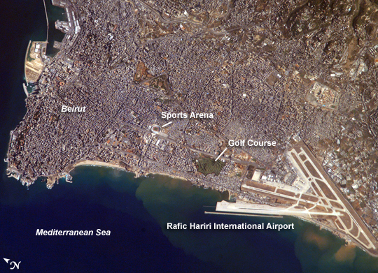 |
| Beirut Metropolitan Area, Lebanon The capital of Lebanon, Beirut, is located along the southeastern shoreline of the Mediterranean Sea. The metropolitan area is built on a small peninsula composed mainly of sedimentary rock deposited over the past 100 million years or so. The growth of the city eastwards is bounded by foothills of the more mountainous interior of Lebanon (image upper right). While this sedimentary platform is stable, the country of Lebanon is located along a major transform fault zone. Transform faults are places where tectonic plates are moving against each other laterally, in this case the African Plate on the west and the Arabian Plate to the east. This tectonic activity creates an earthquake hazard for the country. The Roum Fault, one of the fault strands that is part of the transform boundary, is located directly to the south of the Beirut metropolitan area. The Beirut area has a long human history. It has been an urban center for the past 5,000 years. Throughout much of that time, the region has been the focus of both military and economic conflicts among neighboring city-states. Conflict between Lebanon and Israel in 2006 resulted in environmental damage from an oil spill that affected local beaches. Beach contamination from the oil spill is not visible in this astronaut photograph taken in 2007. Other distinctive features visible in this astronaut photograph include the Rafic Hariri Airport at image lower right, the city sports arena at image center, and several areas of green and open space, including a large golf course at image center. Also visible in the image are several plumes of sediment along the coastline; the most striking plumes are near the airport. The general lack of vegetation in the airport may allow more soil transport by surface water runoff or wind. |
| Images: | All Available Images Low-Resolution 346k |
|
| Mission: | ISS016 |
|
| Roll - Frame: | E - 8436 |
|
| Geographical Name: | LEBANON |
|
| Features: | BEIRUT METROPOLITAN AREA |
|
| Center Lat x Lon: | 33.9N x 35.5E |
|
| Film Exposure: | N=Normal exposure, U=Under exposed, O=Over exposed, F=out of Focus |
|
| Percentage of Cloud Cover-CLDP: | 10 |
|
| Camera:: | E4 |
|
| Camera Tilt: | 50 | LO=Low Oblique, HO=High Oblique, NV=Near Vertical |
| Camera Focal Length: | 800 |
|
| Nadir to Photo Center Direction: | SW | The direction from the nadir to the center point, N=North, S=South, E=East, W=West |
| Stereo?: | Y=Yes there is an adjacent picture of the same area, N=No there isn't |
|
| Orbit Number: | 3146 |
|
| Date: | 20071026 | YYYYMMDD |
| Time: | 072324 | GMT HHMMSS |
| Nadir Lat: | 36.5N |
Latitude of suborbital point of spacecraft |
| Nadir Lon: | 38.1E |
Longitude of suborbital point of spacecraft |
| Sun Azimuth: | 147 | Clockwise angle in degrees from north to the sun measured at the nadir point |
| Space Craft Altitude: | 182 | nautical miles |
| Sun Elevation: | 35 | Angle in degrees between the horizon and the sun, measured at the nadir point |
| Land Views: | FAULT, PENINSULA |
|
| Water Views: | SEA, SEDIMENT |
|
| Atmosphere Views: | |
|
| Man Made Views: | AIRPORT |
|
| City Views: | BEIRUT |
|
Photo is not associated with any sequences | ||
| NASA Home Page |
JSC Home Page |
JSC Digital Image Collection |
Earth Science & Remote Sensing |
|
This service is provided by the International Space Station program and the JSC Earth Science & Remote Sensing Unit, ARES Division, Exploration Integration Science Directorate.

|