Geographic Region: NEW ZEALAND-NI
Feature: WELLINGTON METRO AREA
|
Geographic Region: NEW ZEALAND-NI Feature: WELLINGTON METRO AREA |
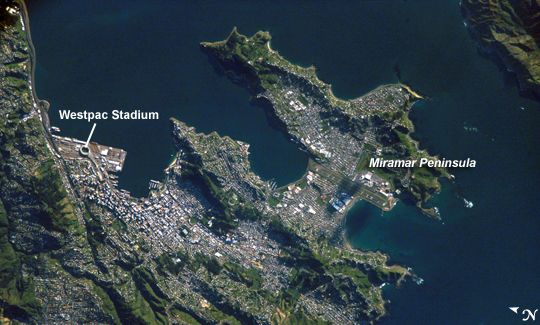 |
| ISS016-E-005121 (21 Oct. 2007) --- Wellington, New Zealand is featured in this image photographed by an Expedition 16 crewmember on the International Space Station. New Zealand's capital of Wellington is located at the southwestern tip of North Island near the Cook Strait. The city is the second largest in New Zealand (after Auckland), and at 41 degrees south latitude, it is the southernmost capital city of the world. The North and South Islands of New Zealand are located along the active Australian-Pacific tectonic plate boundary -- the Islands are only a small part of a larger submerged fragment of continental crust. The glancing collision of these two tectonic plates results in uplift of the land surface, expressed as low hills on North Island and the Southern Alps on South Island. Local topography visible in this view is a result of these tectonic forces and weathering processes, which have exerted a strong influence on the morphology of the city. Tightly clustered white rooftops and high building density of the central business district are visible to the south of the Westpac Stadium between vegetated (green) northeast-southwest trending ridges. Lower density development (gray gridded regions with scattered white rooftops) has spread eastwards along the Miramar Peninsula. Five major faults that run through the Wellington metropolitan area; the largest magnitude earthquake recorded in New Zealand (approximately 8.2 on the Richter Scale) occurred in 1855 on one of these (the Wairarapa Fault). Recognition of the potential seismic hazard in the metropolitan area has led to adoption of building codes to maximize structural resistance to earthquake damage. Wellington, New Zealand: New Zealand's capital, Wellington, sits at the southwestern tip of North Island near the Cook Strait. The city in the second largest in New Zealand (after Auckland), and at 41 south latitude, it is the southernmost capital city in the world. The North and South Islands of New Zealand are located along the active Australian-Pacific tectonic plate boundary. The glancing collision of these two tectonic plates results in uplift of the land surface, expressed as low hills on North Island and the Southern Alps on South Island. Local topography visible in this astronaut photograph is a result of these tectonic forces and weathering, and the topography has exerted a strong influence on the shape of the city. The tightly clustered white rooftops of the central business district are visible to the south of the Westpac Stadium between vegetated (green) northeast-southwest trending ridges. Lower density development (gray gridded areas with scattered white rooftops) has spread eastwards along the Miramar Peninsula. Five major faults run through the Wellington metropolitan area; the largest magnitude earthquake recorded in New Zealand (about 8.2 magnitude) occurred in 1855 on one of these faults. Recognizing the potential seismic hazard, the city has adopted building codes that maximize structural resistance to earthquake damage. |
| Images: | All Available Images Low-Resolution 283k |
|
| Mission: | ISS016 |
|
| Roll - Frame: | E - 5121 |
|
| Geographical Name: | NEW ZEALAND-NI |
|
| Features: | WELLINGTON METRO AREA |
|
| Center Lat x Lon: | 41.3S x 174.8E |
|
| Film Exposure: | N=Normal exposure, U=Under exposed, O=Over exposed, F=out of Focus |
|
| Percentage of Cloud Cover-CLDP: | 10 |
|
| Camera:: | E4 |
|
| Camera Tilt: | 48 | LO=Low Oblique, HO=High Oblique, NV=Near Vertical |
| Camera Focal Length: | 800 |
|
| Nadir to Photo Center Direction: | SW | The direction from the nadir to the center point, N=North, S=South, E=East, W=West |
| Stereo?: | Y=Yes there is an adjacent picture of the same area, N=No there isn't |
|
| Orbit Number: | 3074 |
|
| Date: | 20071021 | YYYYMMDD |
| Time: | 185404 | GMT HHMMSS |
| Nadir Lat: | 39.3S |
Latitude of suborbital point of spacecraft |
| Nadir Lon: | 177.6E |
Longitude of suborbital point of spacecraft |
| Sun Azimuth: | 89 | Clockwise angle in degrees from north to the sun measured at the nadir point |
| Space Craft Altitude: | 188 | nautical miles |
| Sun Elevation: | 18 | Angle in degrees between the horizon and the sun, measured at the nadir point |
| Land Views: | FAULT, ISLAND, PENINSULA |
|
| Water Views: | STRAIT |
|
| Atmosphere Views: | |
|
| Man Made Views: | |
|
| City Views: | WELLINGTON |
|
Photo is not associated with any sequences | ||
| NASA Home Page |
JSC Home Page |
JSC Digital Image Collection |
Earth Science & Remote Sensing |
|
This service is provided by the International Space Station program and the JSC Earth Science & Remote Sensing Unit, ARES Division, Exploration Integration Science Directorate.

|