
Geographic Region: MEXICO
Feature: CERRO CULIACAN,RADIAL DRAINAGE
|
Geographic Region: MEXICO Feature: CERRO CULIACAN,RADIAL DRAINAGE |
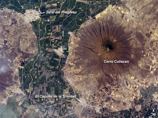 |
| Cerro Culiacan, Guanajuato, Mexico This astronaut photograph highlights Cerro (Spanish for "hill") Culiacan, part of the 50,000 km2 Michoacan-Guanajuato volcanic field of west-central Mexico. The volcanic field contains over 1400 known vents, with cinder cones being the dominant landform. Cerro Culiacan however, is a shield volcano formed by basaltic lavas; it most likely formed during the Pleistocene Epoch approximately 10,000 to 2 million years ago. Shield volcanoes in the Michoacan-Guanajuato field tend to have steeper slopes than similar volcanic structures elsewhere (namely Iceland; this is perhaps due to slightly higher-viscosity lavas), and the 1100-meter high Cerro Culiacan is no exception. The permeable, highly fractured basalt of Culiacan is an important component of the local hydrology. Precipitation that falls on the slopes of the hill swiftly infiltrates down into sediments of the valley floor, providing sufficient moisture to support agriculture (green and brown fields at image center) and, in turn, several small cities such as Jaral del Progreso and El Capulin de la Trinidad (light gray regions with street grids). Precipitation has also incised the slopes of Cerro Culiacan with a radial drainage pattern, extending outwards from the peak in all directions much like the spokes of a bicycle wheel. |
| Images: | All Available Images Low-Resolution 314k |
|
| Mission: | ISS016 |
|
| Roll - Frame: | E - 31086 |
|
| Geographical Name: | MEXICO |
|
| Features: | CERRO CULIACAN,RADIAL DRAINAGE |
|
| Center Lat x Lon: | 20.3N x 100.9W |
|
| Film Exposure: | N=Normal exposure, U=Under exposed, O=Over exposed, F=out of Focus |
|
| Percentage of Cloud Cover-CLDP: | 10 |
|
| Camera:: | E4 |
|
| Camera Tilt: | 32 | LO=Low Oblique, HO=High Oblique, NV=Near Vertical |
| Camera Focal Length: | 400 |
|
| Nadir to Photo Center Direction: | S | The direction from the nadir to the center point, N=North, S=South, E=East, W=West |
| Stereo?: | Y=Yes there is an adjacent picture of the same area, N=No there isn't |
|
| Orbit Number: | 1190 |
|
| Date: | 20080303 | YYYYMMDD |
| Time: | 200012 | GMT HHMMSS |
| Nadir Lat: | 22.2N |
Latitude of suborbital point of spacecraft |
| Nadir Lon: | 101.3W |
Longitude of suborbital point of spacecraft |
| Sun Azimuth: | 210 | Clockwise angle in degrees from north to the sun measured at the nadir point |
| Space Craft Altitude: | 183 | nautical miles |
| Sun Elevation: | 58 | Angle in degrees between the horizon and the sun, measured at the nadir point |
| Land Views: | HILL, VALLEY, VOLCANO |
|
| Water Views: | |
|
| Atmosphere Views: | |
|
| Man Made Views: | AGRICULTURE |
|
| City Views: | |
|
Photo is not associated with any sequences | ||
| NASA Home Page |
JSC Home Page |
JSC Digital Image Collection |
Earth Science & Remote Sensing |
|
This service is provided by the International Space Station program and the JSC Earth Science & Remote Sensing Unit, ARES Division, Exploration Integration Science Directorate.

|