 Photo #: ISS016-E-27034 Date: Feb. 2008
Geographic Region: UK-ENGLAND
Feature: PAN-BRITISH ISLES AT NIGHT
|
Photo #: ISS016-E-27034 Date: Feb. 2008 Geographic Region: UK-ENGLAND Feature: PAN-BRITISH ISLES AT NIGHT |
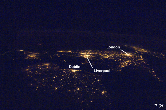 |
| A regional night time panorama of population centers in the United Kingdom. |
| Images: | All Available Images Low-Resolution 272k |
|
| Mission: | ISS016 |
|
| Roll - Frame: | E - 27034 |
|
| Geographical Name: | UK-ENGLAND |
|
| Features: | PAN-BRITISH ISLES AT NIGHT |
|
| Center Lat x Lon: | 54.5N x 3W |
|
| Film Exposure: | N=Normal exposure, U=Under exposed, O=Over exposed, F=out of Focus |
|
| Percentage of Cloud Cover-CLDP: | 0 |
|
| Camera:: | N1 |
|
| Camera Tilt: | HO | LO=Low Oblique, HO=High Oblique, NV=Near Vertical |
| Camera Focal Length: | 28 |
|
| Nadir to Photo Center Direction: | E | The direction from the nadir to the center point, N=North, S=South, E=East, W=West |
| Stereo?: | Y=Yes there is an adjacent picture of the same area, N=No there isn't |
|
| Orbit Number: | 703 |
|
| Date: | 20080201 | YYYYMMDD |
| Time: | 232149 | GMT HHMMSS |
| Nadir Lat: | 50.7N |
Latitude of suborbital point of spacecraft |
| Nadir Lon: | 17W |
Longitude of suborbital point of spacecraft |
| Sun Azimuth: | 313 | Clockwise angle in degrees from north to the sun measured at the nadir point |
| Space Craft Altitude: | 178 | nautical miles |
| Sun Elevation: | -49 | Angle in degrees between the horizon and the sun, measured at the nadir point |
| Land Views: | |
|
| Water Views: | |
|
| Atmosphere Views: | NIGHT |
|
| Man Made Views: | |
|
| City Views: | LONDON,DUBLIN,LIVERPOOL |
|
Photo is not associated with any sequences | ||
| NASA Home Page |
JSC Home Page |
JSC Digital Image Collection |
Earth Science & Remote Sensing |

This service is provided by the International Space Station program and the JSC Earth Science & Remote Sensing Unit, ARES Division, Exploration Integration Science Directorate.

|