Geographic Region: ATLANTIC OCEAN
Feature: ICEBERG A53A, FRAGMENTS
|
Geographic Region: ATLANTIC OCEAN Feature: ICEBERG A53A, FRAGMENTS |
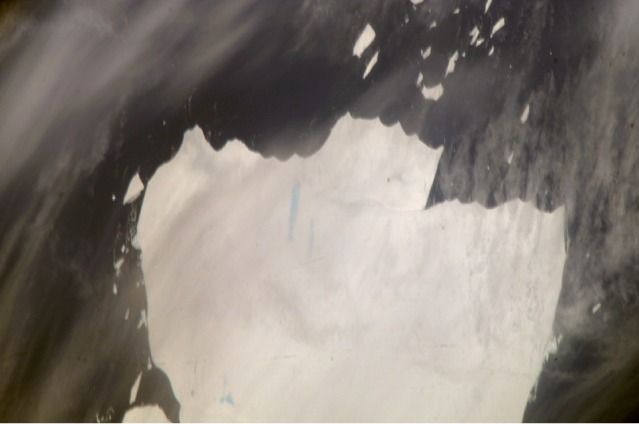 |
| Mega-iceberg A53a, South Atlantic The mega-iceberg A53a (upper image) measured close to 50 kilometers by 22 kilometers, about seven times the area of Manhattan Island, in mid-January 2008 when astronauts took the photographs for this mosaic. The images were acquired from the International Space Station (ISS), located 780 kilometers to the north of the iceberg at an altitude of 341 kilometers; the perspective distorts the oblong shape of the iceberg, making it look squarer than it actually is. At the time the photographs were taken, A53a lay southwest of the remote South Georgia Islands archipelago at approximately 55.5 degrees south, 38.25 degrees west-far to the east of Tierra del Fuego at the southern tip of South America. Gray linear patches at the bottom of the image are thin clouds. Blue patches and streaks on the iceberg are melt ponds. The existence of melt ponds, combined with high summer temperatures, suggest to glaciologists that this iceberg is fast approaching the point of breaking up, probably within a few months. Ted Scambos, glaciologist and Lead Scientist at the National Snow and Ice Data Center, comments, "This is an iceberg worth watching, because, being water-saturated, it may well show a sudden, crumbling, disintegration, spreading fine blue micro-icebergs over the ocean surface." Three detailed images of mega-iceberg A53a were stitched together by Ted Scambos to make this image. The lower image shows A53a in the process of breaking off from the Larsen Ice Shelf in late 2004; the future ice berg is indicated by a dashed line in the image. The wider view of the ice shelf is based on the MODIS Mosaic of Antarctica image map. Some features acquired during the iceberg's calving have been maintained in the years since. Icebergs of the southern Atlantic Ocean contain rock material from Antarctica, eroded by the moving ice, and also wind-borne dust from deserts in Africa, South America, and Australia. The finest powdery rock material acts as nutrients for sea organisms. As the sediment-laden icebergs melt, they enrich the surrounding seawater with minerals. The area of enrichment is significantly larger when a mega-iceberg disintegrates into many small pieces. Because of the capacity to take high-resolution photos at oblique angles through gaps in cloud cover, astronaut photography from the ISS is a unique resource for documenting the break up of major icebergs. As part of NASA's International Polar Year activities, images of A53a and other large icebergs are being acquired from the ISS to support a study of massive icebergs. The study is aimed at understanding the way entire ice shelves-such as those that surround Antarctica today-evolve as climate changes. When large masses of ice float into warmer waters north of their usual latitudes, they undergo change at rapidly increased rates. Changes that would take decades to occur in Antarctica can happen in a few years or even months at latitudes near 50 degrees south. Observing these changes in mega-icebergs can educate scientists about the process of ice shelf breakup. Astronauts have observed other major icebergs in the South Atlantic Ocean, for example, the berg identified as A22a. |
| Images: | All Available Images Low-Resolution 22k |
|
| Mission: | ISS016 |
|
| Roll - Frame: | E - 23197 |
|
| Geographical Name: | ATLANTIC OCEAN |
|
| Features: | ICEBERG A53A, FRAGMENTS |
|
| Center Lat x Lon: | 55.1S x 39.4W |
|
| Film Exposure: | N=Normal exposure, U=Under exposed, O=Over exposed, F=out of Focus |
|
| Percentage of Cloud Cover-CLDP: | 25 |
|
| Camera:: | E4 |
|
| Camera Tilt: | HO | LO=Low Oblique, HO=High Oblique, NV=Near Vertical |
| Camera Focal Length: | 800 |
|
| Nadir to Photo Center Direction: | S | The direction from the nadir to the center point, N=North, S=South, E=East, W=West |
| Stereo?: | Y=Yes there is an adjacent picture of the same area, N=No there isn't |
|
| Orbit Number: | 430 |
|
| Date: | 20080115 | YYYYMMDD |
| Time: | 165525 | GMT HHMMSS |
| Nadir Lat: | 48.6S |
Latitude of suborbital point of spacecraft |
| Nadir Lon: | 37.2W |
Longitude of suborbital point of spacecraft |
| Sun Azimuth: | 303 | Clockwise angle in degrees from north to the sun measured at the nadir point |
| Space Craft Altitude: | 184 | nautical miles |
| Sun Elevation: | 51 | Angle in degrees between the horizon and the sun, measured at the nadir point |
| Land Views: | |
|
| Water Views: | ICE, OCEAN |
|
| Atmosphere Views: | |
|
| Man Made Views: | |
|
| City Views: | |
|
Photo is not associated with any sequences | ||
| NASA Home Page |
JSC Home Page |
JSC Digital Image Collection |
Earth Science & Remote Sensing |
|
This service is provided by the International Space Station program and the JSC Earth Science & Remote Sensing Unit, ARES Division, Exploration Integration Science Directorate.

|