Geographic Region: AUSTRALIA-WA
Feature: PERTH METRO AREA,APPLECROSS
|
Geographic Region: AUSTRALIA-WA Feature: PERTH METRO AREA,APPLECROSS |
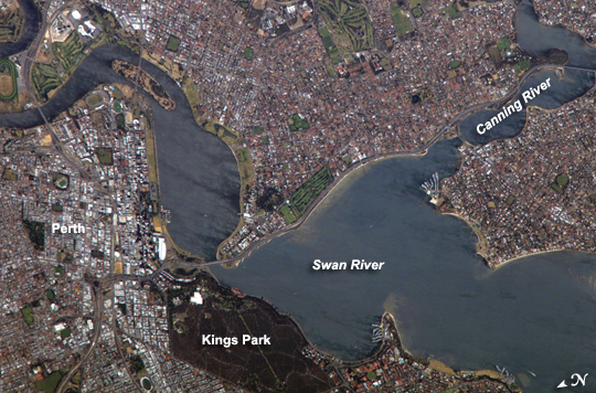 |
| Perth, Australia Perth is the capital of the state of Western Australia, and it is the largest city of the southwestern part of the continent, with an estimated population of over 1.5 million (as of December 2006). The downtown area of Perth and the surrounding suburbs are located on flood plain deposits of the Swan and Canning Rivers, which flow through the center of the metropolitan area. Perth enjoys a Mediterranean climate, where the summers are hot and dry, and winters are cool and moist. Wildfires can develop during the summer months; several large fires threatened the eastern portion of the metropolitan area in 2005. This astronaut photograph captures variations in urban land cover around Perth. The downtown center of the city (image left) is characterized by large buildings (such as skyscrapers) with white, reflective rooftops. Suburbs to the south (across the Swan River) are characterized by higher density of small buildings with predominantly reddish-purple roofs. Several areas of green vegetation are visible in the image. Parks and golf courses comprised mainly of grass present an even, green coloration, while the dense tree canopy of Kings Park appears dark green. Variations in the color of the Swan and Canning Rivers is due to sunglint, or light reflected off the water surface directly back to the observer (in this case, an astronaut about the International Space Station) like a mirror. |
| Images: | All Available Images Low-Resolution 301k |
|
| Mission: | ISS016 |
|
| Roll - Frame: | E - 22772 |
|
| Geographical Name: | AUSTRALIA-WA |
|
| Features: | PERTH METRO AREA,APPLECROSS |
|
| Center Lat x Lon: | 31.9S x 115.8E |
|
| Film Exposure: | N=Normal exposure, U=Under exposed, O=Over exposed, F=out of Focus |
|
| Percentage of Cloud Cover-CLDP: | 10 |
|
| Camera:: | E4 |
|
| Camera Tilt: | 23 | LO=Low Oblique, HO=High Oblique, NV=Near Vertical |
| Camera Focal Length: | 800 |
|
| Nadir to Photo Center Direction: | E | The direction from the nadir to the center point, N=North, S=South, E=East, W=West |
| Stereo?: | Y=Yes there is an adjacent picture of the same area, N=No there isn't |
|
| Orbit Number: | 360 |
|
| Date: | 20080111 | YYYYMMDD |
| Time: | 062104 | GMT HHMMSS |
| Nadir Lat: | 31.7S |
Latitude of suborbital point of spacecraft |
| Nadir Lon: | 114.5E |
Longitude of suborbital point of spacecraft |
| Sun Azimuth: | 284 | Clockwise angle in degrees from north to the sun measured at the nadir point |
| Space Craft Altitude: | 183 | nautical miles |
| Sun Elevation: | 63 | Angle in degrees between the horizon and the sun, measured at the nadir point |
| Land Views: | FLOOD PLAIN |
|
| Water Views: | RIVER, SUNGLINT |
|
| Atmosphere Views: | |
|
| Man Made Views: | |
|
| City Views: | PERTH |
|
Photo is not associated with any sequences | ||
| NASA Home Page |
JSC Home Page |
JSC Digital Image Collection |
Earth Science & Remote Sensing |
|
This service is provided by the International Space Station program and the JSC Earth Science & Remote Sensing Unit, ARES Division, Exploration Integration Science Directorate.

|