
Geographic Region: FRANCE
Feature: PARIS METROPOLITAN AREA
|
Geographic Region: FRANCE Feature: PARIS METROPOLITAN AREA |
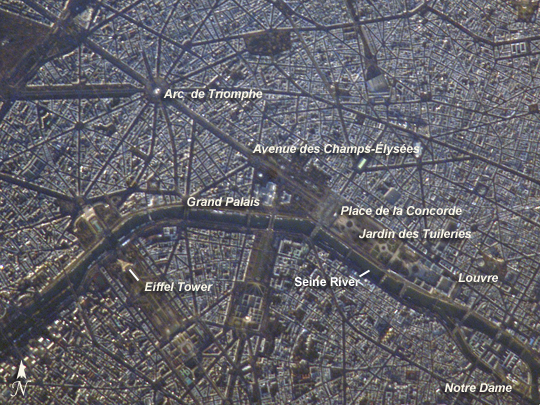 |
| Paris, France A crisp, clear winter day over France provided the International Space Station a detailed view of the city of Paris. This image, rotated and cropped from the original, shows the recognizable street pattern of the city - and some of the world's most notable landmarks - along the Seine River. One of the main avenues radiating like spokes from the Arc de Triomphe (image upper left) is the Avenue des Champs-Elysees running southeast to the Garden of Tuileries (Jardin des Tuileries). The garden--recognizable by its light green color relative to the surrounding built materials--was originally commissioned by Catherine de Medici in 1559, and is now bounded by the Place de la Concorde to the northeast and the Louvre museum along the Seine River at the southeast end. Other, similarly colored parks and greenspaces are visible throughout the image. Farther south on the Seine is the Ile de la Cite, location of the famous Notre Dame cathedral. Perhaps most prominent is the characteristic "A" profile of the Eiffel Tower west of the Jardin des Tuileries, highlighted by morning sunlight. |
| Images: | All Available Images Low-Resolution 363k |
|
| Mission: | ISS016 |
|
| Roll - Frame: | E - 21564 |
|
| Geographical Name: | FRANCE |
|
| Features: | PARIS METROPOLITAN AREA |
|
| Center Lat x Lon: | 48.9N x 2.3E |
|
| Film Exposure: | N=Normal exposure, U=Under exposed, O=Over exposed, F=out of Focus |
|
| Percentage of Cloud Cover-CLDP: | 10 |
|
| Camera:: | E4 |
|
| Camera Tilt: | 50 | LO=Low Oblique, HO=High Oblique, NV=Near Vertical |
| Camera Focal Length: | 800 |
|
| Nadir to Photo Center Direction: | E | The direction from the nadir to the center point, N=North, S=South, E=East, W=West |
| Stereo?: | Y=Yes there is an adjacent picture of the same area, N=No there isn't |
|
| Orbit Number: | 299 |
|
| Date: | 20080107 | YYYYMMDD |
| Time: | 091049 | GMT HHMMSS |
| Nadir Lat: | 49.6N |
Latitude of suborbital point of spacecraft |
| Nadir Lon: | 1.1W |
Longitude of suborbital point of spacecraft |
| Sun Azimuth: | 139 | Clockwise angle in degrees from north to the sun measured at the nadir point |
| Space Craft Altitude: | 177 | nautical miles |
| Sun Elevation: | 8 | Angle in degrees between the horizon and the sun, measured at the nadir point |
| Land Views: | |
|
| Water Views: | RIVER |
|
| Atmosphere Views: | |
|
| Man Made Views: | |
|
| City Views: | PARIS |
|
Photo is not associated with any sequences | ||
| NASA Home Page |
JSC Home Page |
JSC Digital Image Collection |
Earth Science & Remote Sensing |
|
This service is provided by the International Space Station program and the JSC Earth Science & Remote Sensing Unit, ARES Division, Exploration Integration Science Directorate.

|