Geographic Region: ETHIOPIA
Feature: BEDADA TOLA,ENYO,CRATER
|
Geographic Region: ETHIOPIA Feature: BEDADA TOLA,ENYO,CRATER |
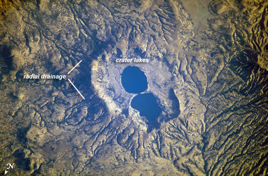 |
| Dendi Caldera, Ethiopia The Dendi Caldera is located on the Ethiopian Plateau, approximately 86 km to the southwest of Addis Ababa. A caldera is a geological feature formed by the near-total eruption of magma from beneath a volcano, leading to collapse of the volcanic structure into the now-empty magma chamber. This collapse typically leaves a crater or depression where the volcano stood, and later volcanic activity can fill the caldera with younger lavas, ash, pyroclastic rocks, and sediments. While much of the volcanic rock in the area is comprised of basalt erupted as part of the opening of the East African Rift, more silica-rich rock types (characterized by minerals such as quartz and feldspar) are also present. The approximately 4 km wide Dendi Caldera includes some of this silica-rich volcanic rock - the rim of the caldera, visible in this astronaut photograph, is comprised mainly of poorly-consolidated ash erupted during the Tertiary Period (approximately 65 - 2 million years ago).A notable feature of the Dendi Caldera is the presence of two shallow lakes formed within the central depression (image center). This image also highlights a radial drainage pattern surrounding the remnants of the Dendi volcanic cone. Such patterns typically form around volcanoes, as rainfall has equal potential to move downslope on all sides of the cone and incise channels. No historical volcanic eruptions of Dendi are recorded, however the Wonchi Caldera 13 km to the southwest (not shown) may have been active as recently as A.D. 550. |
| Images: | All Available Images Low-Resolution 344k |
|
| Mission: | ISS016 |
|
| Roll - Frame: | E - 19239 |
|
| Geographical Name: | ETHIOPIA |
|
| Features: | BEDADA TOLA,ENYO,CRATER |
|
| Center Lat x Lon: | 8.8N x 38.0E |
|
| Film Exposure: | N=Normal exposure, U=Under exposed, O=Over exposed, F=out of Focus |
|
| Percentage of Cloud Cover-CLDP: | 10 |
|
| Camera:: | E4 |
|
| Camera Tilt: | 31 | LO=Low Oblique, HO=High Oblique, NV=Near Vertical |
| Camera Focal Length: | 400 |
|
| Nadir to Photo Center Direction: | SE | The direction from the nadir to the center point, N=North, S=South, E=East, W=West |
| Stereo?: | Y=Yes there is an adjacent picture of the same area, N=No there isn't |
|
| Orbit Number: | 160 |
|
| Date: | 20071229 | YYYYMMDD |
| Time: | 141257 | GMT HHMMSS |
| Nadir Lat: | 10.4N |
Latitude of suborbital point of spacecraft |
| Nadir Lon: | 37.1E |
Longitude of suborbital point of spacecraft |
| Sun Azimuth: | 243 | Clockwise angle in degrees from north to the sun measured at the nadir point |
| Space Craft Altitude: | 181 | nautical miles |
| Sun Elevation: | 14 | Angle in degrees between the horizon and the sun, measured at the nadir point |
| Land Views: | CALDERA, CRATER, PLATEAU, RIFT, VOLCANO |
|
| Water Views: | |
|
| Atmosphere Views: | |
|
| Man Made Views: | |
|
| City Views: | |
|
Photo is not associated with any sequences | ||
| NASA Home Page |
JSC Home Page |
JSC Digital Image Collection |
Earth Science & Remote Sensing |
|
This service is provided by the International Space Station program and the JSC Earth Science & Remote Sensing Unit, ARES Division, Exploration Integration Science Directorate.

|