
Geographic Region: USA-NEW JERSEY
Feature: PERTH AMBOY,RARITAN BAY
|
Geographic Region: USA-NEW JERSEY Feature: PERTH AMBOY,RARITAN BAY |
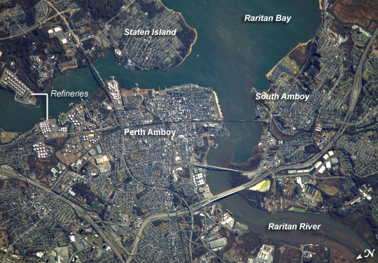 |
| Perth Amboy, New Jersey The port city of Perth Amboy is located between the outlets of the Raritan River and Arthur Kill (kill is "river" in Dutch) into Raritan Bay in upper New Jersey. Rich clay beds in the region, formed during the Cretaceous Era (about 65-144 million years ago), provided raw materials for numerous pottery and terra cotta manufacturers during the nineteenth century. The city was an industrial and shipping center and a resort destination through the early to mid-twentieth century. While the majority of the industrial factory facilities have left Perth Amboy, petroleum processing and storage remains part of the economic base. Several refining facilities are visible along the banks of Arthur Kill in this astronaut photograph (image upper left). Originally known simply as "Amboy," "Perth" was added to the name in honor of the Earl of Perth when the city became the capital of East Jersey in 1686. Together with South Amboy across the Raritan River, both cities are collectively known today as "the Amboys." Perth Amboy is currently undergoing urban renewal and redevelopment to resume its former status as a resort destination. Raritan Bay also provides a source of local income through clam fishing. However, the unwillingness of clams to observe the political border between Staten Island (New York) and New Jersey has led to occasional friction between both states' clammers. |
| Images: | All Available Images Low-Resolution 340k |
|
| Mission: | ISS016 |
|
| Roll - Frame: | E - 18493 |
|
| Geographical Name: | USA-NEW JERSEY |
|
| Features: | PERTH AMBOY,RARITAN BAY |
|
| Center Lat x Lon: | 40.5N x 74.3W |
|
| Film Exposure: | N=Normal exposure, U=Under exposed, O=Over exposed, F=out of Focus |
|
| Percentage of Cloud Cover-CLDP: | 10 |
|
| Camera:: | E4 |
|
| Camera Tilt: | 42 | LO=Low Oblique, HO=High Oblique, NV=Near Vertical |
| Camera Focal Length: | 800 |
|
| Nadir to Photo Center Direction: | E | The direction from the nadir to the center point, N=North, S=South, E=East, W=West |
| Stereo?: | Y=Yes there is an adjacent picture of the same area, N=No there isn't |
|
| Orbit Number: | 82 |
|
| Date: | 20071224 | YYYYMMDD |
| Time: | 151202 | GMT HHMMSS |
| Nadir Lat: | 40.3N |
Latitude of suborbital point of spacecraft |
| Nadir Lon: | 77W |
Longitude of suborbital point of spacecraft |
| Sun Azimuth: | 152 | Clockwise angle in degrees from north to the sun measured at the nadir point |
| Space Craft Altitude: | 178 | nautical miles |
| Sun Elevation: | 21 | Angle in degrees between the horizon and the sun, measured at the nadir point |
| Land Views: | ISLAND |
|
| Water Views: | BAY, RIVER |
|
| Atmosphere Views: | |
|
| Man Made Views: | PORT, RESORT |
|
| City Views: | PERTH AMBOY |
|
Photo is not associated with any sequences | ||
| NASA Home Page |
JSC Home Page |
JSC Digital Image Collection |
Earth Science & Remote Sensing |
|
This service is provided by the International Space Station program and the JSC Earth Science & Remote Sensing Unit, ARES Division, Exploration Integration Science Directorate.

|