Geographic Region: CHILE
Feature: TYNDALL GLACIER,LAKE GEIKIE
|
Geographic Region: CHILE Feature: TYNDALL GLACIER,LAKE GEIKIE |
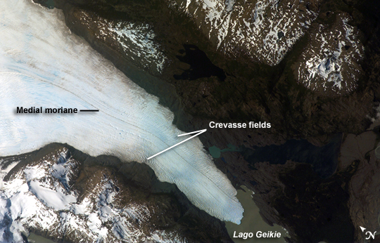 |
| Tyndall Glacier, Chile Tyndall Glacier is located in the Torres del Paine National Park in Chile. This glacier, which has a total area of 331 square kilometers and a length of 32 kilometers (based on 1996 measurements), begins in the Patagonian Andes Mountains to the west and terminates in Lago Geikie. The digital astronaut photograph records visible light in red, green, and blue wavelengths (true color). The Tyndall Glacier terminus has retreated significantly during the past 17 years. Significant ice loss was also observed earlier this year at Grey Glacier, about 30 kilometers to the north-northeast, suggesting both glaciers are responding similarly to regional changes in temperature and precipitation. A medial moraine is visible in the center of the glacier, extending along its length (top image, center left). Moraines--accumulations of soil and rock debris--form along the edges of a glacier as it flows downhill across the landscape (much like a snowplow builds ridges of snow along the roadside). Glaciers flowing downslope through adjacent valleys merge when they encounter each other, and debris entrained along their sides becomes concentrated in the central portion of the new combined ice mass, much as small streams join to form a river. Crevasse fields are also visible in the image. The crevasses--small, but potentially quite deep fissures--form as a result of stress between slower- and faster-moving ice within the glacier. Crevasse fields on Tyndall Glacier are most evident near rock promontories extending into the glacier; these rock outcrops cause the ice to slow as it flows around the obstruction. |
| Images: | All Available Images Low-Resolution 230k |
|
| Mission: | ISS016 |
|
| Roll - Frame: | E - 12047 |
|
| Geographical Name: | CHILE |
|
| Features: | TYNDALL GLACIER,LAKE GEIKIE |
|
| Center Lat x Lon: | 51.1S x 73.3W |
|
| Film Exposure: | N=Normal exposure, U=Under exposed, O=Over exposed, F=out of Focus |
|
| Percentage of Cloud Cover-CLDP: | 10 |
|
| Camera:: | E4 |
|
| Camera Tilt: | HO | LO=Low Oblique, HO=High Oblique, NV=Near Vertical |
| Camera Focal Length: | 400 |
|
| Nadir to Photo Center Direction: | E | The direction from the nadir to the center point, N=North, S=South, E=East, W=West |
| Stereo?: | Y=Yes there is an adjacent picture of the same area, N=No there isn't |
|
| Orbit Number: | 3579 |
|
| Date: | 20071122 | YYYYMMDD |
| Time: | 191337 | GMT HHMMSS |
| Nadir Lat: | 51.7S |
Latitude of suborbital point of spacecraft |
| Nadir Lon: | 79.1W |
Longitude of suborbital point of spacecraft |
| Sun Azimuth: | 308 | Clockwise angle in degrees from north to the sun measured at the nadir point |
| Space Craft Altitude: | 186 | nautical miles |
| Sun Elevation: | 50 | Angle in degrees between the horizon and the sun, measured at the nadir point |
| Land Views: | GLACIER |
|
| Water Views: | ICE |
|
| Atmosphere Views: | |
|
| Man Made Views: | |
|
| City Views: | |
|
Photo is not associated with any sequences | ||
| NASA Home Page |
JSC Home Page |
JSC Digital Image Collection |
Earth Science & Remote Sensing |
|
This service is provided by the International Space Station program and the JSC Earth Science & Remote Sensing Unit, ARES Division, Exploration Integration Science Directorate.

|