
Geographic Region: BRAZIL
Feature: SAO SIMAO RES., PARANAIBA R.
|
Geographic Region: BRAZIL Feature: SAO SIMAO RES., PARANAIBA R. |
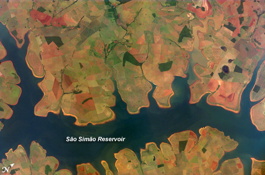 |
| Sao Simao Reservoir, Brazil: 300,000th ISS image of the Earth: The Sao Simao Reservoir, near the confluence of the Rio Paranaiba and Rio Verde in Brazil, is the featured subject in a milestone image of Earth. This colorful, patchwork image is the 300,000th image of Earth downlinked from the International Space Station (ISS). The astronaut photography collection now includes more than 745,000 images of Earth taken by astronaut crews, beginning with the Mercury missions in 1961 and continuing to the present day on the ISS. The Sao Simao Reservoir sits at the border between the states of Goias and Minas Gerais (near the geographic coordinates of 18.7 south, 50.4 west). Though the town of Sao Simao was founded around 1935, major growth occurred when the hydroelectric power plant and dam were built in 1975, forming the reservoir. The reservoir is part of a major navigation route that allows transport of goods between central Brazil, the Prata River, and the South Atlantic. With 600,000 square kilometers of surface area, the reservoir is also a tourist destination for fishing, swimming, and boating. In addition to hydroelectric power production, the economy of the region is based in agribusiness. The image highlights agricultural fields of various kinds and in different stages of cultivation. The major commodities include corn, soybeans, sesame seeds, sugarcane, beans, manioc, coffee, and meat. |
| Images: | All Available Images Low-Resolution 265k |
|
| Mission: | ISS016 |
|
| Roll - Frame: | E - 11999 |
|
| Geographical Name: | BRAZIL |
|
| Features: | SAO SIMAO RES., PARANAIBA R. |
|
| Center Lat x Lon: | 18.7S x 50.4W |
|
| Film Exposure: | N=Normal exposure, U=Under exposed, O=Over exposed, F=out of Focus |
|
| Percentage of Cloud Cover-CLDP: | 0 |
|
| Camera:: | E4 |
|
| Camera Tilt: | 41 | LO=Low Oblique, HO=High Oblique, NV=Near Vertical |
| Camera Focal Length: | 400 |
|
| Nadir to Photo Center Direction: | SE | The direction from the nadir to the center point, N=North, S=South, E=East, W=West |
| Stereo?: | Y=Yes there is an adjacent picture of the same area, N=No there isn't |
|
| Orbit Number: | 3575 |
|
| Date: | 20071122 | YYYYMMDD |
| Time: | 125207 | GMT HHMMSS |
| Nadir Lat: | 17.2S |
Latitude of suborbital point of spacecraft |
| Nadir Lon: | 52.6W |
Longitude of suborbital point of spacecraft |
| Sun Azimuth: | 101 | Clockwise angle in degrees from north to the sun measured at the nadir point |
| Space Craft Altitude: | 185 | nautical miles |
| Sun Elevation: | 56 | Angle in degrees between the horizon and the sun, measured at the nadir point |
| Land Views: | |
|
| Water Views: | RESERVOIR, RIVER |
|
| Atmosphere Views: | |
|
| Man Made Views: | |
|
| City Views: | |
|
Photo is not associated with any sequences | ||
| NASA Home Page |
JSC Home Page |
JSC Digital Image Collection |
Earth Science & Remote Sensing |
|
This service is provided by the International Space Station program and the JSC Earth Science & Remote Sensing Unit, ARES Division, Exploration Integration Science Directorate.

|