
Geographic Region: MEXICO
Feature: GULF OF CALIFORNIA,MAZATLAN
|
Geographic Region: MEXICO Feature: GULF OF CALIFORNIA,MAZATLAN |
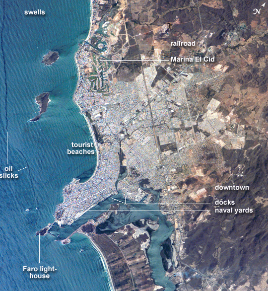 |
| ISS015-E-07934 (13 May 2007) --- Mazatlan, Mexico is featured in this image photographed by an Expedition 15 crewmember on the International Space Station. Mazatlan is Mexico's largest port, situated on one of the best estuaries on Mexico's Pacific coast, illustrated well in this image. Docks and naval yards line the north side of the estuary. The city itself appears as a series of light-toned city blocks covering the center of the image. Mazatlan (population of 352,000 in 2005) is growing northward from the downtown peninsula, with tourist beaches backed by hotels, and a marina and golf courses just beyond. No city growth yet appears on the south side the estuary where farm lands can be seen. The famous Faro Lighthouse occupies the top of a steep island--now connected by a bridge to the mainland--at the mouth of the estuary (top center). The Faro Lighthouse is the second tallest in the world behind Gibraltar's. The wide, straight, almost vertical line of the railroad appears to bisect the picture. This image shows sea features well, primarily ocean swells coming in from the southwest, which appear as a series of parallel lines covering the entire sea surface in this view. An oil slick offshore of the tourist beaches appears as a dark line along the left side of the image. Mazatlan, Mexico: Mazatlan is Mexico's largest port, situated on one of the best estuaries (bottom center of image) on Mexico's Pacific coast. The city appears as a series of light-toned geometric blocks covering the center of this astronaut photograph. The image also shows the docks and naval yards that line the north side of the estuary. Mazatlan (population 352,000 in 2005) is growing northward from the downtown peninsula, with tourist beaches backed by hotels, and a marina and golf courses just beyond. No city growth yet appears on the south side of the estuary, where narrow rectangles of farm land can be seen. The famous Faro Lighthouse occupies the top of a steep island--now connected by a bridge to the mainland--at the mouth of the estuary (image lower left). The Faro Lighthouse is the second tallest in the world, after Gibraltar's. The wide, straight, almost vertical line of the railroad bisects the city. This image shows sea features well, primarily ocean swells coming in from the southwest, which appear as a series of parallel lines covering the entire sea surface in this image. The diverse activities that go on in busy urban areas do not always mix easily: an oil slick offshore of the tourist beaches appears as a dark line along the left side of the image. |
| Images: | All Available Images Low-Resolution 482k |
|
| Mission: | ISS015 |
|
| Roll - Frame: | E - 7934 |
|
| Geographical Name: | MEXICO |
|
| Features: | GULF OF CALIFORNIA,MAZATLAN |
|
| Center Lat x Lon: | 23.2N x 106.3W |
|
| Film Exposure: | N=Normal exposure, U=Under exposed, O=Over exposed, F=out of Focus |
|
| Percentage of Cloud Cover-CLDP: | 10 |
|
| Camera:: | E4 |
|
| Camera Tilt: | 8 | LO=Low Oblique, HO=High Oblique, NV=Near Vertical |
| Camera Focal Length: | 400 |
|
| Nadir to Photo Center Direction: | W | The direction from the nadir to the center point, N=North, S=South, E=East, W=West |
| Stereo?: | Y=Yes there is an adjacent picture of the same area, N=No there isn't |
|
| Orbit Number: | 535 |
|
| Date: | 20070513 | YYYYMMDD |
| Time: | 210431 | GMT HHMMSS |
| Nadir Lat: | 23.2N |
Latitude of suborbital point of spacecraft |
| Nadir Lon: | 105.9W |
Longitude of suborbital point of spacecraft |
| Sun Azimuth: | 267 | Clockwise angle in degrees from north to the sun measured at the nadir point |
| Space Craft Altitude: | 177 | nautical miles |
| Sun Elevation: | 61 | Angle in degrees between the horizon and the sun, measured at the nadir point |
| Land Views: | COAST, ISLAND, PENINSULA |
|
| Water Views: | ESTUARY, OCEAN, SEA |
|
| Atmosphere Views: | |
|
| Man Made Views: | BRIDGE, PORT |
|
| City Views: | MAZATLAN |
|
Photo is not associated with any sequences | ||
| NASA Home Page |
JSC Home Page |
JSC Digital Image Collection |
Earth Science & Remote Sensing |
|
This service is provided by the International Space Station program and the JSC Earth Science & Remote Sensing Unit, ARES Division, Exploration Integration Science Directorate.

|