
Geographic Region: KAZAKHSTAN
Feature: DUST STORM, ARAL SEA
|
Geographic Region: KAZAKHSTAN Feature: DUST STORM, ARAL SEA |
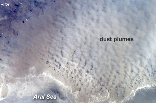 |
| ISS015-E-07874 (12 May 2007) --- A major dust storm (center right) along the east side of the Aral Sea, Kazakhstan, is featured in this image photographed by an Expedition 15 crewmember on the International Space Station while passing over central Asia. The white, irregular lines along the bottom of the image are salt and clay deposits on the present coastline. On the spring day when the ISS crew shot the image, winds were blowing from the west (lower left). The gray, puffy appearance is typical of dust clouds, allowing scientists to distinguish dust from fog and smog. The dust in this image is rising from the sea bed of the Aral Sea, from a point close to the middle of the original Aral Sea of 40--50 years ago, then the fourth largest inland sea on Earth. Heavy extraction of water from the main supply river, the Amu Dary'a, has resulted in rapid shrinking of the sea. According to scientists, dust storms have been occurring in the Aral Sea region for thousands of years, but since the drastic shrinking of the sea over the past half-century an important change in dust composition has occurred. The dust now includes fertilizer and pesticide washed into the Sea from the extensive cotton fields of the Amu Dary'a floodplain. Years of liberal application of agricultural chemicals have resulted in concentration of these pollutants on the sea bed. These are now exposed to the wind and transported hundreds of kilometers in a generally easterly direction. Research suggests that the remobilized chemicals are the cause of high rates of many diseases in the populations along the north, east and southern margins of the Aral Sea. This is one of the unintended consequences of the shrinking of the sea, which has made international news for many years due to the loss of the fishing industry and other significant ecological problems. Dust Storm, Aral Sea, Kazakhstan: Astronauts aboard the International Space Station (ISS) took this image of a major dust storm (image center and right) along the east side of the Aral Sea while passing over central Asia in the spring of 2007. The white, irregular lines along the bottom of the image are salt and clay deposits on the present coastline. The day that the ISS crew shot the image, winds were blowing from the west (lower left). The gray, puffy appearance is typical of dust clouds, allowing scientists to distinguish dust from fog and smog. The dust in this image is rising from the sea bed of the Aral Sea, from a point close to the middle of the original Aral Sea of 1950s and 1960s--at that time the fourth-largest inland sea on Earth. During the next several decades, heavy extraction of water from the main supply river, the Amu Dary'a, resulted in rapid shrinking of the sea. Dust storms have occurred over the Aral Sea region for thousands of years, but the half-century of drastic shrinking of the sea brought an important change in dust composition. By the time this photograph was taken, the dust included fertilizer and pesticide washed into the inland sea from the extensive cotton fields of the Amu Dary'a floodplain. Years of liberal application of agricultural chemicals resulted in concentration of these pollutants on the seabed, now exposed to the wind and transported hundreds of kilometers in a generally easterly direction. Research suggests that the remobilized chemicals are the cause of high rates of many diseases in the populations along the north, east, and southern margins of the Aral Sea. Negative health effects were only one of the unexpected consequences of the shrinking of the sea, whose retreat made international news for many years due to the loss of the fishing industry and other significant ecological problems. Another negative consequence was the loss of the stabilizing influence of a large body of water on the region's continental climate (cold winters combined with hot, dry summers). Large bodies of water cool down and heat up more gradually than land surfaces, so they moderate both extreme cold and extreme heat. Since the decline of the Aral Sea, summers have become shorter and hotter, and winters are longer; overall, the climate is drier. Frosts occur later in the spring and earlier in the fall, shortening the growing season. Restoration efforts are underway for the North Aral Sea, which has been cut off from the South Aral Sea by a dam. In spring 2007, scientists announced that the North Aral Sea was refilling more rapidly than they originally expected. References Micklin, P. (1998). Desiccation of the Aral Sea: A water management disaster in the Soviet Union. Science, 241, 1170-1176. doi:10.1126/science.241.4870.1170 |
| Images: | All Available Images Low-Resolution 208k |
|
| Mission: | ISS015 |
|
| Roll - Frame: | E - 7874 |
|
| Geographical Name: | KAZAKHSTAN |
|
| Features: | DUST STORM, ARAL SEA |
|
| Center Lat x Lon: | 45.2N x 60.8E |
|
| Film Exposure: | N=Normal exposure, U=Under exposed, O=Over exposed, F=out of Focus |
|
| Percentage of Cloud Cover-CLDP: | 10 |
|
| Camera:: | E4 |
|
| Camera Tilt: | HO | LO=Low Oblique, HO=High Oblique, NV=Near Vertical |
| Camera Focal Length: | 180 |
|
| Nadir to Photo Center Direction: | E | The direction from the nadir to the center point, N=North, S=South, E=East, W=West |
| Stereo?: | Y=Yes there is an adjacent picture of the same area, N=No there isn't |
|
| Orbit Number: | 511 |
|
| Date: | 20070512 | YYYYMMDD |
| Time: | 082520 | GMT HHMMSS |
| Nadir Lat: | 48.0N |
Latitude of suborbital point of spacecraft |
| Nadir Lon: | 52.1E |
Longitude of suborbital point of spacecraft |
| Sun Azimuth: | 179 | Clockwise angle in degrees from north to the sun measured at the nadir point |
| Space Craft Altitude: | 177 | nautical miles |
| Sun Elevation: | 60 | Angle in degrees between the horizon and the sun, measured at the nadir point |
| Land Views: | |
|
| Water Views: | SEA |
|
| Atmosphere Views: | DUST |
|
| Man Made Views: | |
|
| City Views: | |
|
Photo is not associated with any sequences | ||
| NASA Home Page |
JSC Home Page |
JSC Digital Image Collection |
Earth Science & Remote Sensing |
|
This service is provided by the International Space Station program and the JSC Earth Science & Remote Sensing Unit, ARES Division, Exploration Integration Science Directorate.

|