
Geographic Region: USA-UTAH
Feature: CANYONLANDS UPHEAVAL DOME
|
Geographic Region: USA-UTAH Feature: CANYONLANDS UPHEAVAL DOME |
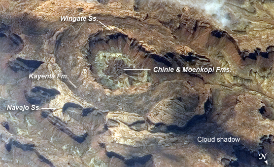 |
| Upheaval Dome, Utah: Upheaval Dome is a striking geologic structure in the Canyonlands National Park of southern Utah. Viewed from directly above (and on geologic maps), the alternating rock layers make a nearly circular, 5.5-kilometer- (3.4-mile-) diameter "bull's-eye." The oldest rocks are in the center (Chinle and Moenkopi Formations, with limited exposures of even older rocks), and progressively younger rocks are exposed farther out: Wingate Sandstone, Kayenta Formation, and Navajo Sandstone (in order of decreasing age). This kind of rock formation--a fold in the Earth's crust in which the rocks slope downward from either side of a central point--is called an anticline. If the exposed rock layers form a closed circle at the surface, the anticline is called a dome. It is typical of these formations for the central rocks to be the oldest. This photograph of Upheaval Dome was taken by an astronaut onboard the International Space Station. The oblique viewing angle--in other words, not looking straight down--provides a sense of the topography within and around the structure. The dome appears more like an ellipse than a circle due to the oblique viewing perspective. Dark regions in the image are cloud and cliff shadows. Scientists propose at least two ideas about how Upheaval Dome formed. Some believe that the dome is a sign of a sub-surface salt dome--a rising plug of relatively low-density salt that caused overlying rock layers to dome up in a circular pattern like a basketball underneath a blanket. The overlying rock layers were uplifted and then eroded, leaving the bull's-eye surface pattern. Another hypothesis identifies Upheaval Dome as an impact structure, caused by a meteor striking the Earth approximately 60 million years ago. In this interpretation, the erosion-resistant Navajo and Wingate Sandstones define multiple crater rings, while the Chinle, Moenkopi, and older rocks exposed in the middle of the dome are the central peak of the impact structure. Debate about the origin of Upheaval Dome continues; recent evidence--such as microscale deformations of the rocks and minerals that are consistent with a high-energy impact event--lends support to the impact-structure hypothesis. |
| Images: | All Available Images Low-Resolution 287k |
|
| Mission: | ISS015 |
|
| Roll - Frame: | E - 5983 |
|
| Geographical Name: | USA-UTAH |
|
| Features: | CANYONLANDS UPHEAVAL DOME |
|
| Center Lat x Lon: | 38.4N x 109.9W |
|
| Film Exposure: | N=Normal exposure, U=Under exposed, O=Over exposed, F=out of Focus |
|
| Percentage of Cloud Cover-CLDP: | 10 |
|
| Camera:: | E4 |
|
| Camera Tilt: | 35 | LO=Low Oblique, HO=High Oblique, NV=Near Vertical |
| Camera Focal Length: | 800 |
|
| Nadir to Photo Center Direction: | SW | The direction from the nadir to the center point, N=North, S=South, E=East, W=West |
| Stereo?: | Y=Yes there is an adjacent picture of the same area, N=No there isn't |
|
| Orbit Number: | 344 |
|
| Date: | 20070501 | YYYYMMDD |
| Time: | 181856 | GMT HHMMSS |
| Nadir Lat: | 40.1N |
Latitude of suborbital point of spacecraft |
| Nadir Lon: | 108.7W |
Longitude of suborbital point of spacecraft |
| Sun Azimuth: | 151 | Clockwise angle in degrees from north to the sun measured at the nadir point |
| Space Craft Altitude: | 179 | nautical miles |
| Sun Elevation: | 63 | Angle in degrees between the horizon and the sun, measured at the nadir point |
| Land Views: | CRATER, EROSION |
|
| Water Views: | |
|
| Atmosphere Views: | |
|
| Man Made Views: | |
|
| City Views: | |
|
Photo is not associated with any sequences | ||
| NASA Home Page |
JSC Home Page |
JSC Digital Image Collection |
Earth Science & Remote Sensing |
|
This service is provided by the International Space Station program and the JSC Earth Science & Remote Sensing Unit, ARES Division, Exploration Integration Science Directorate.

|