
Geographic Region: USA-NEW YORK
Feature: BUFFALO,NIAGARA FALLS
|
Geographic Region: USA-NEW YORK Feature: BUFFALO,NIAGARA FALLS |
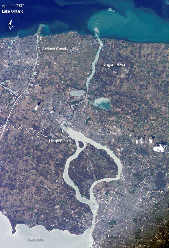 |
| Springtime Comes to the Niagara River: (image is paired with/compared to image ISS014-E-17999) What a difference a month makes! These two images of the Niagara River draining Lake Erie (bottom) into Lake Ontario (top) were acquired about a month apart (March 21 and April 29, 2007, respectively) from the International Space Station. The pair documents the breakup of the Lake Erie ice pack, the unofficial signature of spring for residents of Buffalo and Niagara Falls. In March, the eastern end of Lake Erie is clogged with ice that is pushed against the shoreline by the prevailing westerly wind. The ice collects in Lake Erie, and the Lake Erie-Niagara River Ice Boom prevents it from flowing down the Niagara River, which is the international boundary between the Canadian Province of Ontario, and New York State. The 2,680-meter (8,800-foot) boom is deployed each December. Operational since 1964, the boom serves several functions: it protects the water intakes for the Niagara River power plants, and it minimizes ice runs (large blocks of ice flowing downstream as ice breaks up in the spring) and blockages that can create damage and flooding along the river. At the height of winter, the thickness of the ice at the Buffalo harbor can reach 3.5 meters (12 feet). The removal of the ice boom, usually in early April, is now marked by local celebrations. This year the boom was removed in mid-April, a bit later than usual. A webcam allows remote viewers to monitor ice pack at the boom. During their missions, astronauts track the changing seasons using such indicators as the springtime melting of ice packs in high-latitude oceans and lakes. Over the next two years, the space station astronauts will make these types of observations to support International Polar Year (IPY) investigations. |
| Images: | All Available Images Low-Resolution 648k |
|
| Mission: | ISS015 |
|
| Roll - Frame: | E - 5624 |
|
| Geographical Name: | USA-NEW YORK |
|
| Features: | BUFFALO,NIAGARA FALLS |
|
| Center Lat x Lon: | 43.1N x 79W |
|
| Film Exposure: | N=Normal exposure, U=Under exposed, O=Over exposed, F=out of Focus |
|
| Percentage of Cloud Cover-CLDP: | 10 |
|
| Camera:: | E4 |
|
| Camera Tilt: | HO | LO=Low Oblique, HO=High Oblique, NV=Near Vertical |
| Camera Focal Length: | 180 |
|
| Nadir to Photo Center Direction: | W | The direction from the nadir to the center point, N=North, S=South, E=East, W=West |
| Stereo?: | Y=Yes there is an adjacent picture of the same area, N=No there isn't |
|
| Orbit Number: | 312 |
|
| Date: | 20070429 | YYYYMMDD |
| Time: | 174112 | GMT HHMMSS |
| Nadir Lat: | 46.8N |
Latitude of suborbital point of spacecraft |
| Nadir Lon: | 71.5W |
Longitude of suborbital point of spacecraft |
| Sun Azimuth: | 205 | Clockwise angle in degrees from north to the sun measured at the nadir point |
| Space Craft Altitude: | 173 | nautical miles |
| Sun Elevation: | 56 | Angle in degrees between the horizon and the sun, measured at the nadir point |
| Land Views: | |
|
| Water Views: | FLOODING, ICE, LAKE, RIVER |
|
| Atmosphere Views: | |
|
| Man Made Views: | HARBOR |
|
| City Views: | BUFFALO |
|
Photo is not associated with any sequences | ||
| NASA Home Page |
JSC Home Page |
JSC Digital Image Collection |
Earth Science & Remote Sensing |
|
This service is provided by the International Space Station program and the JSC Earth Science & Remote Sensing Unit, ARES Division, Exploration Integration Science Directorate.

|