
Geographic Region: USA-NEW YORK
Feature: BROOKLYN,UPPER BAY,FORT JAY
|
Geographic Region: USA-NEW YORK Feature: BROOKLYN,UPPER BAY,FORT JAY |
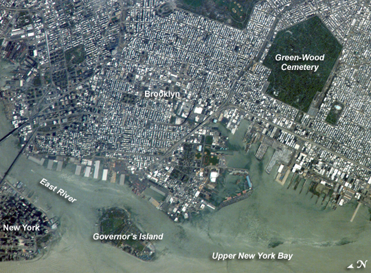 |
| ISS015-E-05483 (28 April 2007) --- Brooklyn, New York waterfront is featured in this image photographed by an Expedition 15 crewmember on the International Space Station. This view illustrates the dense urban fabric of Brooklyn, New York City's largest borough (population of 2.6 million), characterized by the regular pattern of highly reflective building rooftops (white). Two main arteries from Manhattan into Brooklyn, the famous Brooklyn Bridge and neighboring Manhattan Bridge, cross the East River along the left (north) side of the image. The dense built-up fabric contrasts with the East River and Upper New York Bay (bottom center) waterfront areas, recognizable by docks and large industrial loading facilities that extend across the bottom center from left to right. Much of the shipping traffic has moved to the New Jersey side of New York Bay--this has spurred dismantling and redevelopment of the historic dockyards and waterfront warehouses into residential properties. However, efforts to conserve historic buildings are also ongoing. The original name for Brooklyn, Breukelen, means "broken land" in Dutch--perhaps in recognition of the highly mixed deposits (boulders, sand, silt, and clay) left behind by the Wisconsin glacier between 20,000--90,000 years ago, according to scientists. These deposits form much of Long Island, of which Brooklyn occupies the western tip. This image features one of Brooklyn's largest green spaces, the Green-Wood Cemetery. Today, the cemetery functions as both a natural park and a place of internment. The green tree canopy of the Cemetery contrasts sharply with the surrounding urban land cover, is an Audubon Sanctuary, and provides the final resting place for many 19th and 20th century New York celebrities. Also visible in the image is Governor's Island, which served as a strategic military installation for the US Army (1783--1966) and a major US Coast Guard installation (1966--1996). Today the historic fortifications on the island and their surroundings comprise the Governors Island National Monument. Brooklyn, New York Waterfront: This astronaut photograph captures the dense urban fabric of Brooklyn, New York City's largest borough (population of 2.6 million), characterized by the regular pattern of highly reflective building rooftops (white). Two main arteries from Manhattan into Brooklyn--the famous Brooklyn Bridge and neighboring Manhattan Bridge--cross the East River along the left (north) side of the image. The densely built-up landscape contrasts with the East River and Upper New York Bay (image lower right) waterfront areas, recognizable by docks and large industrial loading facilities that extend across the image center from left to right. Much of the shipping traffic has moved to the New Jersey side of New York Bay, a shift that has spurred dismantling and redevelopment of the historic dockyards and waterfront warehouses into residential properties. However, efforts to conserve historic buildings are also ongoing. The original name for Brooklyn, Breukelen, means "broken land" in Dutch, perhaps in recognition of the highly mixed deposits (boulders, sand, silt, and clay) left behind by the Wisconsin glacier between 20,000 and 90,000 years ago. These deposits form much of Long Island, of which Brooklyn occupies the western tip. This image features one of Brooklyn's largest green spaces, the Green-Wood Cemetery. The green canopy of the cemetery's trees contrasts sharply with the surrounding urban land cover. Today, the cemetery also functions as a natural park, and it is an Audubon Sanctuary. Also visible in the image is Governors Island, which served as a strategic military installation for the U.S. Army (1783-1966) and a major U.S. Coast Guard installation (1966-1996). Today the historic fortifications on the island and their surroundings comprise the Governors Island National Monument. |
| Images: | All Available Images Low-Resolution 345k |
|
| Mission: | ISS015 |
|
| Roll - Frame: | E - 5483 |
|
| Geographical Name: | USA-NEW YORK |
|
| Features: | BROOKLYN,UPPER BAY,FORT JAY |
|
| Center Lat x Lon: | 40.6N x 74W |
|
| Film Exposure: | N=Normal exposure, U=Under exposed, O=Over exposed, F=out of Focus |
|
| Percentage of Cloud Cover-CLDP: | 10 |
|
| Camera:: | E4 |
|
| Camera Tilt: | 35 | LO=Low Oblique, HO=High Oblique, NV=Near Vertical |
| Camera Focal Length: | 800 |
|
| Nadir to Photo Center Direction: | SW | The direction from the nadir to the center point, N=North, S=South, E=East, W=West |
| Stereo?: | Y=Yes there is an adjacent picture of the same area, N=No there isn't |
|
| Orbit Number: | 296 |
|
| Date: | 20070428 | YYYYMMDD |
| Time: | 172015 | GMT HHMMSS |
| Nadir Lat: | 41.7N |
Latitude of suborbital point of spacecraft |
| Nadir Lon: | 72.3W |
Longitude of suborbital point of spacecraft |
| Sun Azimuth: | 197 | Clockwise angle in degrees from north to the sun measured at the nadir point |
| Space Craft Altitude: | 174 | nautical miles |
| Sun Elevation: | 62 | Angle in degrees between the horizon and the sun, measured at the nadir point |
| Land Views: | COAST, ISLAND |
|
| Water Views: | BAY, RIVER |
|
| Atmosphere Views: | |
|
| Man Made Views: | BRIDGE |
|
| City Views: | BROOKLYN, MANHATTAN, NEW YORK CITY |
|
Photo is not associated with any sequences | ||
| NASA Home Page |
JSC Home Page |
JSC Digital Image Collection |
Earth Science & Remote Sensing |
|
This service is provided by the International Space Station program and the JSC Earth Science & Remote Sensing Unit, ARES Division, Exploration Integration Science Directorate.

|