
Geographic Region: USA-MARYLAND
Feature: PATUXENT R. AIR TEST CENTER
|
Geographic Region: USA-MARYLAND Feature: PATUXENT R. AIR TEST CENTER |
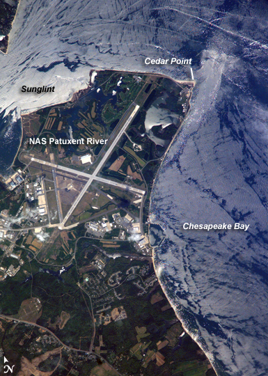 |
| Patuxent River Naval Air Station, Maryland: Maryland's Patuxent River Naval Air Station is located on a small peninsula, bordered by the Patuxent River to the north-northeast and Chesapeake Bay to the east and southeast. The air station was commissioned in 1943, replacing farmlands that had occupied the peninsula less than a year earlier. The primary purpose of "Pax River" (as the site is known by the U.S. Navy) was to consolidate geographically dispersed testing facilities that existed prior to World War II. The Patuxent River station is now the primary center for naval air technology research, development, testing, and support, as well as being the location of the Navy Test Pilot School. International Space Station crews frequently use the Patuxent River Naval Air Station as a geographic reference point and photographic training target. This astronaut photograph illustrates why--the distinctive pattern of the airfield runways and the station's location in Chesapeake Bay make it easy to spot from orbit. The sharp boundaries between different kinds of land surfaces are good for camera focusing practice. This particular image also captures surface water current patterns around the peninsula. Wind- and wave-roughened water surfaces appear silver-gray due to increased reflectance of light back towards the camera (sunglint), whereas dark blue water patches indicate water smoothed by the presence of oils and surfactants (smooth water reflects less light back to the observer) from either natural or human sources. A zone of mixing from converging shoreline currents extends northeast into the bay from Cedar Point. |
| Images: | Images: | NO IMAGES YET | |||
| Mission: | ISS015 |
||||
| Roll - Frame: | E - 5481 |
||||
| Geographical Name: | USA-MARYLAND |
||||
| Features: | PATUXENT R. AIR TEST CENTER |
||||
| Center Lat x Lon: | 38.3N x 76.4W |
||||
| Film Exposure: | N=Normal exposure, U=Under exposed, O=Over exposed, F=out of Focus |
||||
| Percentage of Cloud Cover-CLDP: | 10 |
||||
| Camera:: | E4 |
||||
| Camera Tilt: | 25 | LO=Low Oblique, HO=High Oblique, NV=Near Vertical |
|||
| Camera Focal Length: | 800 |
||||
| Nadir to Photo Center Direction: | S | The direction from the nadir to the center point, N=North, S=South, E=East, W=West |
|||
| Stereo?: | Y=Yes there is an adjacent picture of the same area, N=No there isn't |
||||
| Orbit Number: | 296 |
||||
| Date: | 20070428 | YYYYMMDD |
|||
| Time: | 171919 | GMT HHMMSS |
|||
| Nadir Lat: | 39.6N |
Latitude of suborbital point of spacecraft | |||
| Nadir Lon: | 76W |
Longitude of suborbital point of spacecraft | |||
| Sun Azimuth: | 190 | Clockwise angle in degrees from north to the sun measured at the nadir point |
|||
| Space Craft Altitude: | 174 | nautical miles |
|||
| Sun Elevation: | 64 | Angle in degrees between the horizon and the sun, measured at the nadir point |
|||
| Land Views: | PENINSULA |
||||
| Water Views: | BAY, RIVER, SUNGLINT, WAVE |
||||
| Atmosphere Views: | |
||||
| Man Made Views: | |
||||
| City Views: | |
||||
Photo is not associated with any sequences | |||||
| NASA Home Page |
JSC Home Page |
JSC Digital Image Collection |
Earth Science & Remote Sensing |
|
This service is provided by the International Space Station program and the JSC Earth Science & Remote Sensing Unit, ARES Division, Exploration Integration Science Directorate.

|