Geographic Region: FALKLAND ISLANDS
Feature: EAST ISLAND, FALKLAND SOUND
|
Geographic Region: FALKLAND ISLANDS Feature: EAST ISLAND, FALKLAND SOUND |
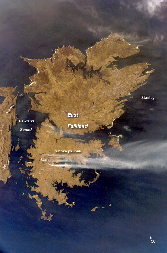 |
| ISS015-E-30526 (25 Sept. 2007) --- Fires in East Falkland Island in the South Atlantic Ocean are featured in this image photographed by an Expedition 15 crewmember on the International Space Station. The Falkland Islands are an overseas territory of the United Kingdom, referred to by Argentina (which also claims the islands) as the Islas Malvinas. The main islands of East Falkland and West Falkland are separated by Falkland Sound (12 kilometers) wide at the narrow point. Together they total about the same area as the State of Connecticut or Northern Ireland. The islands lie almost 500 kilometers from the Argentine coast and less than 1,000 kilometers from Antarctica. The first air links to these remote islands were only put in place in 1971. The capital city of Stanley lies on the eastern tip of East Falkland. The local inhabitants are mainly English speakers, and interestingly, the islands have become a center of English-language learning for students from South America. The windy and relatively dry climate has given rise to natural vegetation comprised of treeless grassland with scattered bogs. The grasslands are ideal for sheep rearing which was the dominant occupation until recent decades, when fishing (mainly squid to Spain) and tourism became the mainstay of the economy. These expanses of grassland provide ready fuel for fires, as indicated by the several long smoke plumes visible in this image. Fires, East Falkland Island, South Atlantic: The Falkland Islands are an overseas territory of the United Kingdom, referred to by Argentina (which also claims the islands) as the Islas Malvinas. Falkland Sound, which is 12 kilometers (7.5 miles) wide at the narrow point, separates the main islands of East Falkland (image center) and West Falkland (along image left). Together they total about the same area as the State of Connecticut or Northern Ireland. The islands lie almost 500 kilometers (310 miles) from the Argentine coast and less than 1,000 kilometers (620 miles) from Antarctica. The first flights to these remote islands were only implemented in 1971. The capital city of Stanley lies on the eastern tip of East Falkland. The local inhabitants are mainly English speakers, and interestingly, the islands have become a center of English-language learning for students from South America. The windy and relatively dry climate, which receives roughly 600 millimeters (24 inches) of precipitation annually, has given rise to natural vegetation comprised of treeless grassland with scattered bogs. The grasslands are ideal for sheep rearing--the dominant occupation until recent decades, when fishing (mainly squid for Spain) and tourism became the mainstays of the economy. These expanses of grassland provide ready fuel for fires, as indicated by the several long smoke plumes visible in this astronaut photograph. This near-nadir image was acquired at the southernmost extent of the International Space Station's latitudinal orbit range of approximately 52 degrees north to 52 degrees south relative to the surface of the Earth. |
| Images: | All Available Images Low-Resolution 535k |
|
| Mission: | ISS015 |
|
| Roll - Frame: | E - 30526 |
|
| Geographical Name: | FALKLAND ISLANDS |
|
| Features: | EAST ISLAND, FALKLAND SOUND |
|
| Center Lat x Lon: | 51.9S x 58.7W |
|
| Film Exposure: | N=Normal exposure, U=Under exposed, O=Over exposed, F=out of Focus |
|
| Percentage of Cloud Cover-CLDP: | 10 |
|
| Camera:: | E4 |
|
| Camera Tilt: | 26 | LO=Low Oblique, HO=High Oblique, NV=Near Vertical |
| Camera Focal Length: | 58 |
|
| Nadir to Photo Center Direction: | W | The direction from the nadir to the center point, N=North, S=South, E=East, W=West |
| Stereo?: | Y=Yes there is an adjacent picture of the same area, N=No there isn't |
|
| Orbit Number: | 2664 |
|
| Date: | 20070925 | YYYYMMDD |
| Time: | 183813 | GMT HHMMSS |
| Nadir Lat: | 51.2S |
Latitude of suborbital point of spacecraft |
| Nadir Lon: | 57.3W |
Longitude of suborbital point of spacecraft |
| Sun Azimuth: | 308 | Clockwise angle in degrees from north to the sun measured at the nadir point |
| Space Craft Altitude: | 189 | nautical miles |
| Sun Elevation: | 28 | Angle in degrees between the horizon and the sun, measured at the nadir point |
| Land Views: | COAST, ISLAND |
|
| Water Views: | OCEAN |
|
| Atmosphere Views: | SMOKE |
|
| Man Made Views: | |
|
| City Views: | |
|
Photo is not associated with any sequences | ||
| NASA Home Page |
JSC Home Page |
JSC Digital Image Collection |
Earth Science & Remote Sensing |
|
This service is provided by the International Space Station program and the JSC Earth Science & Remote Sensing Unit, ARES Division, Exploration Integration Science Directorate.

|