
Geographic Region: USA-NEBRASKA
Feature: NORTH PLATTE RIVER,SAND HILLS
|
Geographic Region: USA-NEBRASKA Feature: NORTH PLATTE RIVER,SAND HILLS |
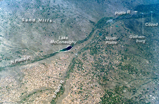 |
| ISS015-E-27232 (5 Sept. 2007) --- North and South Platte Rivers, Nebraska are featured in this image photographed by an Expedition 15 crewmember on the International Space Station. Lake McConaughy and thousands of rectangular tan and green agricultural fields of western Nebraska and northeastern Colorado dominate this oblique scene. The crewmember that shot this view was looking towards the east-northeast, focusing on the thin, green lines of the floodplains of the North and South Platte rivers. These join to form the Platte River near upper right. The Platte river system has determined transportation routes for centuries. Modern Highway 80 follows the North Platte and Highway 76 the South Platte. The presence of transport routes and rivers--as sources of water in a semiarid region--in turn determine the location of towns: the city of North Platte stands out as a light gray area on the floodplain at the confluence of the North and South Platte rivers, as do two smaller towns, Gothenburg and Cozad, further downstream (top right). The distribution of cropland visible in this image is also interesting to geographers. The flattest surfaces are easiest to farm and have the highest areal density of farmed fields. These flat surfaces lie on the river floodplains, but are also present on the higher surrounding surfaces. Between the heavily cultivated land in the river floodplain and the uplands is a strip of rough country that is difficult to farm. As a result, it stands out as a gray strip running parallel to the green croplands of the floodplains. The famous Nebraska Sand Hills, recognizable by their characteristic scalloped texture north of the lake at center, are a hummocky dune field (now vegetated) and are thus also largely devoid of fields. Westernmost Nebraska has been abnormally dry in the last three months--covering the time when this image was taken (Sept. 5). This water deficit can be seen on the image in terms of grass cover health: browner (drier) surfaces occupy the dry regions (lower left), and greener (moister) surfaces appear further east (right). North and South Platte Rivers, Nebraska: Lake McConaughy and a tan-and-green patchwork of thousands of agricultural fields dominate this astronaut photo of western Nebraska and northeastern Colorado. The astronaut who shot this view was looking towards the east-northeast, focusing on the thin, green lines of the floodplains of the North and South Platte rivers. These join to form the Platte River near image upper right. From a geographical perspective, the photograph demonstrates how the Platte River system has determined transportation and settlement patterns for centuries. Modern Highway 80 follows the North Platte, and Highway 76 follows the South Platte. The presence of transport routes and rivers--as sources of water in a semiarid region--in turn determine the location of towns: the city of North Platte stands out as a light gray area on the floodplain at the confluence of the North and South Platte rivers, as do two smaller towns, Gothenburg and Cozad, farther downstream (image top right). The distribution of cropland visible in this image also reveals interesting geographical information about the characteristics of the land surface. The flattest surfaces are easiest to farm and have the highest density of farmed fields. These flat surfaces lie on the river floodplains, but are also present on the higher surrounding surfaces. Between the heavily cultivated land in the river floodplain and the uplands is a strip of rough country that is difficult to farm. As a result, it stands out as a gray strip running parallel to the green croplands of the floodplains. The famous Nebraska Sand Hills, recognizable by their characteristic scalloped texture north of Lake McConaughty, are a hummocky sand dune field (now vegetated). According to the U.S. Drought Monitor, westernmost Nebraska was abnormally dry in the last three months--covering the time when this image was taken (September 5, 2007). The impact of the water deficit on grass cover can be seen in the image: dry areas are brown (image lower left), and moister areas farther east are greener (image right). |
| Images: | All Available Images Low-Resolution 321k |
|
| Mission: | ISS015 |
|
| Roll - Frame: | E - 27232 |
|
| Geographical Name: | USA-NEBRASKA |
|
| Features: | NORTH PLATTE RIVER,SAND HILLS |
|
| Center Lat x Lon: | 41.1N x 101.5W |
|
| Film Exposure: | N=Normal exposure, U=Under exposed, O=Over exposed, F=out of Focus |
|
| Percentage of Cloud Cover-CLDP: | 10 |
|
| Camera:: | E4 |
|
| Camera Tilt: | 53 | LO=Low Oblique, HO=High Oblique, NV=Near Vertical |
| Camera Focal Length: | 70 |
|
| Nadir to Photo Center Direction: | E | The direction from the nadir to the center point, N=North, S=South, E=East, W=West |
| Stereo?: | Y=Yes there is an adjacent picture of the same area, N=No there isn't |
|
| Orbit Number: | 2350 |
|
| Date: | 20070905 | YYYYMMDD |
| Time: | 202130 | GMT HHMMSS |
| Nadir Lat: | 41.0N |
Latitude of suborbital point of spacecraft |
| Nadir Lon: | 105.5W |
Longitude of suborbital point of spacecraft |
| Sun Azimuth: | 213 | Clockwise angle in degrees from north to the sun measured at the nadir point |
| Space Craft Altitude: | 184 | nautical miles |
| Sun Elevation: | 51 | Angle in degrees between the horizon and the sun, measured at the nadir point |
| Land Views: | DUNE |
|
| Water Views: | LAKE, RIVER |
|
| Atmosphere Views: | |
|
| Man Made Views: | HIGHWAY |
|
| City Views: | GOTHENBURG |
|
Photo is not associated with any sequences | ||
| NASA Home Page |
JSC Home Page |
JSC Digital Image Collection |
Earth Science & Remote Sensing |
|
This service is provided by the International Space Station program and the JSC Earth Science & Remote Sensing Unit, ARES Division, Exploration Integration Science Directorate.

|