Geographic Region: RUSSIAN FEDERATION
Feature: SIMUSHIR I.,ZAVARITZKI VOLCANO
|
Geographic Region: RUSSIAN FEDERATION Feature: SIMUSHIR I.,ZAVARITZKI VOLCANO |
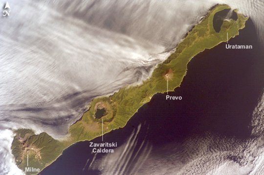 |
| ISS015-E-26171 (1 Sept. 2007) --- Simushir Island, Kuril Archipelago, Russian Far East, is featured in this image photographed by an Expedition 15 crewmember on the International Space Station. Simushir is a deserted, 5-mile-wide volcanic island in the Kuril island chain, half way between northern Japan and the Kamchatka Peninsula of Russia. Four volcanoes - Milne, Prevo, Urataman and Zavaritski - have built cones that are high enough to rise above the altitude of green forest. The remaining remnant of Zavaritski volcano is a caldera -- a structure formed when a volcano collapses into its emptied magma chamber. A small lake fills the innermost of three nested calderas which make up Zavaritski Caldera. The larger caldera of Urataman Volcano is connected to the sea. A defunct Soviet naval base occupies the northern tip of the island next to this caldera. The islands and volcanoes of the Kuril chain are part of the Pacific Rim of Fire, marking the edge of the Pacific tectonic plate. Low stratus clouds approaching from the northwest (from the Sea of Okhotsk--top left) bank up against the northwest side of the island, making complex cloud patterns. A small finger of cloud can be seen entering the northernmost caldera (Urataman) at sea level. When this image was taken, the cloud layer had stopped at the northwest coast of the island, not flowing over even the low points of the island between the volcanoes. The cloud pattern suggests that the air mass flowed up and over the island, descending on the southeast side. This descending motion was enough--under stable atmospheric conditions--to warm up the atmosphere locally so that a cloud-free zone formed on the southeastern, lee side of the island. Simushir Island, Kuril Archipelago: Simushir is a deserted, 5-mile-wide volcanic island in the Kuril Islands chain, half way between northern Japan and the Kamchatka Peninsula of Russia. Four volcanoes--Milne, Prevo, Urataman, and Zavaritski--have built cones tall enough to rise above the green forest. The remaining remnant of Zavaritski Volcano is a caldera, formed when a volcano collapses into its emptied magma chamber. A small lake fills the innermost of three nested calderas that make up Zavaritski Caldera. The larger caldera of Urataman Volcano is connected to the sea. The islands and volcanoes of the Kuril chain are part of the Pacific "Ring of Fire," marking the edge of the Pacific tectonic plate. Low stratus clouds approaching from the northwest (from the Sea of Okhotsk) bank against the northwest side of the island, forming complex cloud patterns. A small finger of cloud enters the northernmost caldera (Urataman) at sea level. When this image was taken, the cloud layer had stopped at the island's northwest coast, not flowing over even the low points between the volcanoes. The cloud pattern suggests that an air mass flowed up and over the island, descending on the southeast side. When air rises, it often cools; water vapor in the air condenses into cloud droplets. When air sinks, it often warms, causing cloud droplets to evaporate. It appears that in this situation, the descending motion of the air warmed the atmosphere enough so that a cloud-free zone formed on the southeastern, lee side, of the island. |
| Images: | All Available Images Low-Resolution 223k |
|
| Mission: | ISS015 |
|
| Roll - Frame: | E - 26171 |
|
| Geographical Name: | RUSSIAN FEDERATION |
|
| Features: | SIMUSHIR I.,ZAVARITZKI VOLCANO |
|
| Center Lat x Lon: | 47.0N x 152.0E |
|
| Film Exposure: | N=Normal exposure, U=Under exposed, O=Over exposed, F=out of Focus |
|
| Percentage of Cloud Cover-CLDP: | 50 |
|
| Camera:: | E4 |
|
| Camera Tilt: | 17 | LO=Low Oblique, HO=High Oblique, NV=Near Vertical |
| Camera Focal Length: | 180 |
|
| Nadir to Photo Center Direction: | NW | The direction from the nadir to the center point, N=North, S=South, E=East, W=West |
| Stereo?: | Y=Yes there is an adjacent picture of the same area, N=No there isn't |
|
| Orbit Number: | 2289 |
|
| Date: | 20070901 | YYYYMMDD |
| Time: | 231905 | GMT HHMMSS |
| Nadir Lat: | 46.3N |
Latitude of suborbital point of spacecraft |
| Nadir Lon: | 152.6E |
Longitude of suborbital point of spacecraft |
| Sun Azimuth: | 128 | Clockwise angle in degrees from north to the sun measured at the nadir point |
| Space Craft Altitude: | 181 | nautical miles |
| Sun Elevation: | 40 | Angle in degrees between the horizon and the sun, measured at the nadir point |
| Land Views: | CALDERA, COAST, FOREST, ISLAND, PENINSULA, VOLCANO |
|
| Water Views: | LAKE, SEA |
|
| Atmosphere Views: | |
|
| Man Made Views: | |
|
| City Views: | |
|
Photo is not associated with any sequences | ||
| NASA Home Page |
JSC Home Page |
JSC Digital Image Collection |
Earth Science & Remote Sensing |
|
This service is provided by the International Space Station program and the JSC Earth Science & Remote Sensing Unit, ARES Division, Exploration Integration Science Directorate.

|