Geographic Region: ATLANTIC OCEAN
Feature: A22A ICEBERG, SMALL ICEBERGS
|
Geographic Region: ATLANTIC OCEAN Feature: A22A ICEBERG, SMALL ICEBERGS |
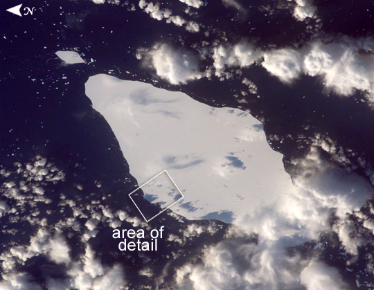 |
| Iceberg A22A, South Atlantic Ocean This astronaut photograph illustrates the remains of a giant iceberg--designated A22A-- that broke off Antarctica in 2002. The iceberg was photographed on May 30 at a location of 49.9 degrees south latitude, 23.8 degrees west longitude, which is about a third of the distance from South America towards Cape Town, South Africa. A22A is one of the largest icebergs to drift as far north as 50 degrees south latitude, bringing it beneath the daylight path of the International Space Station (ISS). Crew members aboard the ISS were able to locate the ice mass and photograph it, despite the great masses of clouds that often accompany winter storms in the Southern Ocean. The crew's viewing angle was oblique (not looking straight down) from a point to the west of the berg, and the time of day was early afternoon, as shown by the orientation of the cloud shadows. Dimensions of A22A in early June were 49.9 by 23.4 kilometers, giving it an area of 622 square kilometers, or seven times the area of Manhattan Island. The outlined region labeled "Area of Detail" refers to an associated image ISS015-E-10118. Images of the iceberg are being acquired from the ISS to support a study of massive icebergs--part of NASA International Polar Year activities. The study will increase understanding of the way ice sheets evolve as climate changes. When large masses of ice float into warmer waters north of their usual latitudes, they undergo change at rapidly increased rates. Changes that would take decades to occur in Antarctica can happen in a few years or even months in the warmer conditions at 50 degrees south latitude. The crew of the ISS will continue to collect imagery of the accelerating breakup of iceberg A22A as weather, orbital, and illumination conditions allow. More information, including Webcams, on the studies conducted on A22 and at other places in the Antarctic can be found at www.thistle.org and the National Snow and Ice Data Center's Icetrek Website (//nsidc.org/icetrek/). |
| Images: | All Available Images Low-Resolution 226k |
|
| Mission: | ISS015 |
|
| Roll - Frame: | E - 10125 |
|
| Geographical Name: | ATLANTIC OCEAN |
|
| Features: | A22A ICEBERG, SMALL ICEBERGS |
|
| Center Lat x Lon: | 48.8S x 24W |
|
| Film Exposure: | N=Normal exposure, U=Under exposed, O=Over exposed, F=out of Focus |
|
| Percentage of Cloud Cover-CLDP: | 50 |
|
| Camera:: | E4 |
|
| Camera Tilt: | 43 | LO=Low Oblique, HO=High Oblique, NV=Near Vertical |
| Camera Focal Length: | 180 |
|
| Nadir to Photo Center Direction: | NW | The direction from the nadir to the center point, N=North, S=South, E=East, W=West |
| Stereo?: | Y=Yes there is an adjacent picture of the same area, N=No there isn't |
|
| Orbit Number: | 799 |
|
| Date: | 20070530 | YYYYMMDD |
| Time: | 144644 | GMT HHMMSS |
| Nadir Lat: | 50.5S |
Latitude of suborbital point of spacecraft |
| Nadir Lon: | 21.8W |
Longitude of suborbital point of spacecraft |
| Sun Azimuth: | 340 | Clockwise angle in degrees from north to the sun measured at the nadir point |
| Space Craft Altitude: | 181 | nautical miles |
| Sun Elevation: | 16 | Angle in degrees between the horizon and the sun, measured at the nadir point |
| Land Views: | ISLAND |
|
| Water Views: | ICE, OCEAN |
|
| Atmosphere Views: | |
|
| Man Made Views: | |
|
| City Views: | |
|
Photo is not associated with any sequences | ||
| NASA Home Page |
JSC Home Page |
JSC Digital Image Collection |
Earth Science & Remote Sensing |
|
This service is provided by the International Space Station program and the JSC Earth Science & Remote Sensing Unit, ARES Division, Exploration Integration Science Directorate.

|