
Geographic Region: USA-LOUISIANA
Feature: LAKE PONTCHARTRAIN,NEW ORLEANS
|
Geographic Region: USA-LOUISIANA Feature: LAKE PONTCHARTRAIN,NEW ORLEANS |
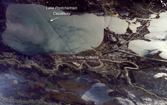 |
| ISS014-E-08179 (18 Nov. 2006) --- New Orleans, Louisiana is featured in this image photographed by an Expedition 14 crewmember on the International Space Station. The location of New Orleans, in a shallow depression within unconsolidated deltaic sediments, makes it particularly vulnerable to subsidence and increased likelihood of flooding. The average elevation of metropolitan New Orleans is 1.8 meters below sea level, and a complicated system of levees, pumps, and upstream control structures on the Mississippi River is necessary to maintain dry conditions in the city. The ground subsidence occurs from groundwater withdrawal, reduction of sediment delivery by the Mississippi River, and land use changes (such as draining of wetlands) associated with continuing development. The low areas can be flooded by river floods, storm surges, or failure of levees holding back surrounding lake waters - as demonstrated catastrophically during Hurricane Katrina in 2005. Sunglint accentuates the wetland setting of New Orleans in this image by highlighting the numerous lakes, pond, and rivers (in various shades of silver-gray) surrounding the city. The view was acquired by a crewmember looking southwest from the station, which was located over north-central Alabama at the time this image was taken. Lake Pontchartrain borders New Orleans to the north, and the Lake Pontchartrain Causeway (36 kilometers in length) appears as a dark linear feature against the lake surface. Variations in surface water coloration to the east and west of the Causeway reflect the dynamics of the surface waters (including surface currents and wind-induced roughening). The patterns are made visible by the presence of surfactants on the water surface. Low cloud cover produces a blue-gray haze visible at lower left. |
| Images: | All Available Images Low-Resolution 245k |
|
| Mission: | ISS014 |
|
| Roll - Frame: | E - 8179 |
|
| Geographical Name: | USA-LOUISIANA |
|
| Features: | LAKE PONTCHARTRAIN,NEW ORLEANS |
|
| Center Lat x Lon: | 30.0N x 90W |
|
| Film Exposure: | N=Normal exposure, U=Under exposed, O=Over exposed, F=out of Focus |
|
| Percentage of Cloud Cover-CLDP: | 10 |
|
| Camera:: | E4 |
|
| Camera Tilt: | HO | LO=Low Oblique, HO=High Oblique, NV=Near Vertical |
| Camera Focal Length: | 180 |
|
| Nadir to Photo Center Direction: | SW | The direction from the nadir to the center point, N=North, S=South, E=East, W=West |
| Stereo?: | Y=Yes there is an adjacent picture of the same area, N=No there isn't |
|
| Orbit Number: | 1755 |
|
| Date: | 20061118 | YYYYMMDD |
| Time: | 191100 | GMT HHMMSS |
| Nadir Lat: | 33.7N |
Latitude of suborbital point of spacecraft |
| Nadir Lon: | 86.5W |
Longitude of suborbital point of spacecraft |
| Sun Azimuth: | 208 | Clockwise angle in degrees from north to the sun measured at the nadir point |
| Space Craft Altitude: | 179 | nautical miles |
| Sun Elevation: | 32 | Angle in degrees between the horizon and the sun, measured at the nadir point |
| Land Views: | |
|
| Water Views: | FLOODING, LAKE, RIVER, SEA, SEDIMENT, SUNGLINT |
|
| Atmosphere Views: | HAZE |
|
| Man Made Views: | |
|
| City Views: | NEW ORLEANS |
|
Photo is not associated with any sequences | ||
| NASA Home Page |
JSC Home Page |
JSC Digital Image Collection |
Earth Science & Remote Sensing |
|
This service is provided by the International Space Station program and the JSC Earth Science & Remote Sensing Unit, ARES Division, Exploration Integration Science Directorate.

|