
Geographic Region: ITALY
Feature: VILLAGGIO BONCORE, RACE TRACK
|
Geographic Region: ITALY Feature: VILLAGGIO BONCORE, RACE TRACK |
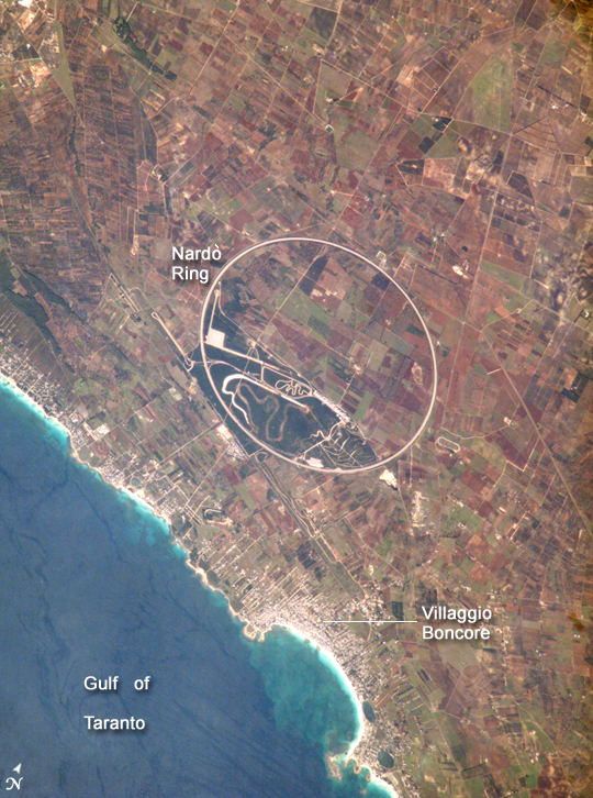 |
| Nardo Ring, Italy: The Nardo Ring is a striking visual feature from space, and astronauts have photographed it several times. The Ring is a race car test track; it is 12.5 kilometers long and steeply banked to reduce the amount of active steering needed by drivers. Although it is a perfect circle, it appears oval in this photograph. This distortion is because the astronaut's viewing angle was 35 degrees, looking back along the orbit track to the southwest from the International Space Station's window. The Nardo Ring lies in a remote area on the heel of Italy's "boot," 50 kilometers east of the naval port of Taranto. The small coastal town of Villaggio Boncore--visible as a light grey area of linear streets at the bottom center of the image--lies just to the south, but the Ring is named after the bigger urban center of Nardo, 22 kilometers to the southeast (not shown). The Ring encompasses a number of active (green) and fallow (brown to dark brown) agricultural fields. In this zone of intensive agriculture, farmers gain access to their fields through the Ring via a series of underpasses. Winding features within the southern section of the Ring appear to be smaller, unused race tracks. |
| Images: | All Available Images Low-Resolution 530k |
|
| Mission: | ISS014 |
|
| Roll - Frame: | E - 7578 |
|
| Geographical Name: | ITALY |
|
| Features: | VILLAGGIO BONCORE, RACE TRACK |
|
| Center Lat x Lon: | 40.3N x 17.8E |
|
| Film Exposure: | N=Normal exposure, U=Under exposed, O=Over exposed, F=out of Focus |
|
| Percentage of Cloud Cover-CLDP: | 10 |
|
| Camera:: | E4 |
|
| Camera Tilt: | 35 | LO=Low Oblique, HO=High Oblique, NV=Near Vertical |
| Camera Focal Length: | 800 |
|
| Nadir to Photo Center Direction: | S | The direction from the nadir to the center point, N=North, S=South, E=East, W=West |
| Stereo?: | Y=Yes there is an adjacent picture of the same area, N=No there isn't |
|
| Orbit Number: | 1591 |
|
| Date: | 20061108 | YYYYMMDD |
| Time: | 093605 | GMT HHMMSS |
| Nadir Lat: | 42.3N |
Latitude of suborbital point of spacecraft |
| Nadir Lon: | 18.5E |
Longitude of suborbital point of spacecraft |
| Sun Azimuth: | 165 | Clockwise angle in degrees from north to the sun measured at the nadir point |
| Space Craft Altitude: | 181 | nautical miles |
| Sun Elevation: | 30 | Angle in degrees between the horizon and the sun, measured at the nadir point |
| Land Views: | |
|
| Water Views: | GULF |
|
| Atmosphere Views: | |
|
| Man Made Views: | AGRICULTURE, PORT |
|
| City Views: | |
|
Photo is not associated with any sequences | ||
| NASA Home Page |
JSC Home Page |
JSC Digital Image Collection |
Earth Science & Remote Sensing |
|
This service is provided by the International Space Station program and the JSC Earth Science & Remote Sensing Unit, ARES Division, Exploration Integration Science Directorate.

|