 Photo #: ISS014-E-7480 Date: Nov. 2006
Geographic Region: USA-TEXAS
Feature: DYESS AIR FORCE BASE, AGR.

 Photo #: ISS014-E-7480 Date: Nov. 2006 Photo #: ISS014-E-7480 Date: Nov. 2006Geographic Region: USA-TEXAS Feature: DYESS AIR FORCE BASE, AGR. |
 |
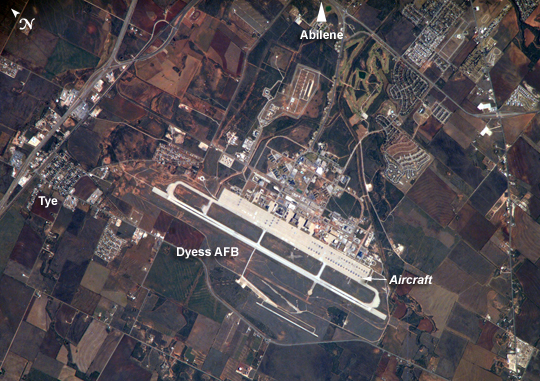
| Dyess Air Force Base: Abilene, Texas: Dyess Air Force Base, located near the central Texas city of Abilene, is the home of the 7thBomb Wing and 317th Airlift Groups of the United States Air Force. The base also conducts all initial Air Force combat crew training for the B-1B Lancer aircraft. The main runway is approximately 5 kilometers long, a distance that is necessary to accommodate the large bombers and cargo aircraft at the base. Many of these aircraft are visible in the image, parked in parallel rows on the base tarmac. Airfields and airports are useful sites for astronauts to hone their technique for using a long camera lens to acquire high-resolution images. The sharp contrast between highly reflective, linear features, such as runways, and darker agricultural fields and undisturbed (vegetated) land allows fine focusing of the cameras. This on-the-job training is crucial for teaching astronauts to obtain not only high-resolution imagery of Earth, but also inspection photographs of the thermal protection tiles on the Space Shuttle during continuing missions to the International Space Station. |
| Images: | All Available Images Low-Resolution 319k |
|
| Mission: | ISS014 |
|
| Roll - Frame: | E - 7480 |
|
| Geographical Name: | USA-TEXAS |
|
| Features: | DYESS AIR FORCE BASE, AGR. |
|
| Center Lat x Lon: | 32.4N x 99.8W |
|
| Film Exposure: | N=Normal exposure, U=Under exposed, O=Over exposed, F=out of Focus |
|
| Percentage of Cloud Cover-CLDP: | 10 |
|
| Camera:: | E4 |
|
| Camera Tilt: | 19 | LO=Low Oblique, HO=High Oblique, NV=Near Vertical |
| Camera Focal Length: | 800 |
|
| Nadir to Photo Center Direction: | E | The direction from the nadir to the center point, N=North, S=South, E=East, W=West |
| Stereo?: | Y=Yes there is an adjacent picture of the same area, N=No there isn't |
|
| Orbit Number: | 1580 |
|
| Date: | 20061107 | YYYYMMDD |
| Time: | 164854 | GMT HHMMSS |
| Nadir Lat: | 32.7N |
Latitude of suborbital point of spacecraft |
| Nadir Lon: | 100.8W |
Longitude of suborbital point of spacecraft |
| Sun Azimuth: | 151 | Clockwise angle in degrees from north to the sun measured at the nadir point |
| Space Craft Altitude: | 183 | nautical miles |
| Sun Elevation: | 36 | Angle in degrees between the horizon and the sun, measured at the nadir point |
| Land Views: | |
|
| Water Views: | |
|
| Atmosphere Views: | |
|
| Man Made Views: | |
|
| City Views: | ABILENE |
|
Photo is not associated with any sequences | ||
| NASA Home Page |
JSC Home Page |
JSC Digital Image Collection |
Earth Science & Remote Sensing |
|
|