
Geographic Region: SWITZERLAND
Feature: GENEVA, AIRPORT, RHONE R., L.
|
Geographic Region: SWITZERLAND Feature: GENEVA, AIRPORT, RHONE R., L. |
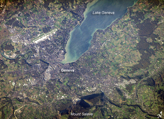 |
| Geneva, Switzerland: The city of Geneva embraces the southern end of Lake Geneva (also known as Lac Leman). Geneva is tucked between two major mountain ranges, the Jura to the northwest (not shown) and the Alps to the southeast. Mount Saleve, near the bottom of the image, represents the northern foothills of the range. The city's built-up area, roadways, and airport appear as white to gray surfaces in this astronaut photograph. Urbanized regions are interspersed with agricultural fields (bright green to light brown rectangular regions) and preserved forest stands (dark green) around the lake. In places, the forest stands cast shadows, giving the scene a three-dimensional feel. The near-shore waters of Lake Geneva are brown with sediment in this scene. The main contributor to Lake Geneva is the Rhone River, which flows in at the northern end and exits in the south. Near the southwestern outskirts of the city, the Rhone is joined by the Arve River, which runs into the city from the southeast. Both rivers have their sources in alpine glaciers. Geneva is primarily known for being a "world city" of cultural, economic, and political significance because it hosts numerous international organizations and corporations, including the European headquarters of the United Nations. |
| Images: | All Available Images Low-Resolution 374k |
|
| Mission: | ISS014 |
|
| Roll - Frame: | E - 7084 |
|
| Geographical Name: | SWITZERLAND |
|
| Features: | GENEVA, AIRPORT, RHONE R., L. |
|
| Center Lat x Lon: | 46.3N x 6.2E |
|
| Film Exposure: | N=Normal exposure, U=Under exposed, O=Over exposed, F=out of Focus |
|
| Percentage of Cloud Cover-CLDP: | 10 |
|
| Camera:: | E4 |
|
| Camera Tilt: | 30 | LO=Low Oblique, HO=High Oblique, NV=Near Vertical |
| Camera Focal Length: | 400 |
|
| Nadir to Photo Center Direction: | S | The direction from the nadir to the center point, N=North, S=South, E=East, W=West |
| Stereo?: | Y=Yes there is an adjacent picture of the same area, N=No there isn't |
|
| Orbit Number: | 1499 |
|
| Date: | 20061102 | YYYYMMDD |
| Time: | 134748 | GMT HHMMSS |
| Nadir Lat: | 48.0N |
Latitude of suborbital point of spacecraft |
| Nadir Lon: | 6.6E |
Longitude of suborbital point of spacecraft |
| Sun Azimuth: | 219 | Clockwise angle in degrees from north to the sun measured at the nadir point |
| Space Craft Altitude: | 179 | nautical miles |
| Sun Elevation: | 19 | Angle in degrees between the horizon and the sun, measured at the nadir point |
| Land Views: | FOREST, MOUNTAIN, RANGE |
|
| Water Views: | LAKE, RIVER, SEDIMENT |
|
| Atmosphere Views: | |
|
| Man Made Views: | AIRPORT |
|
| City Views: | GENEVA |
|
Photo is not associated with any sequences | ||
| NASA Home Page |
JSC Home Page |
JSC Digital Image Collection |
Earth Science & Remote Sensing |
|
This service is provided by the International Space Station program and the JSC Earth Science & Remote Sensing Unit, ARES Division, Exploration Integration Science Directorate.

|