Geographic Region: UK-ENGLAND
Feature: ISLES OF SCILLY, WAVES, SED.
|
Geographic Region: UK-ENGLAND Feature: ISLES OF SCILLY, WAVES, SED. |
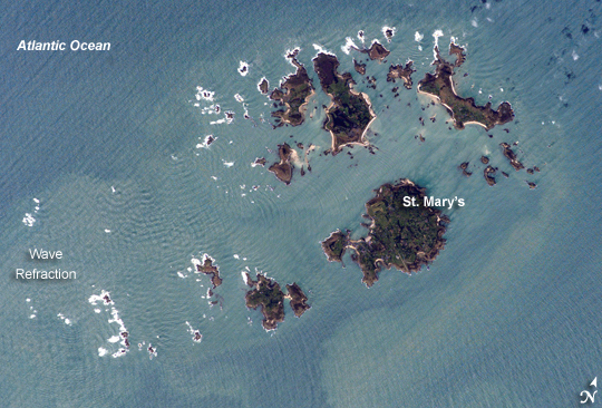 |
| Isles of Scilly, UK: The Isles of Scilly, an archipelago of approximately 150 islands, are located some 44 kilometers southwest of the westernmost point of England (Land's End). The islands are an eroded remnant of granite rock that intruded into the Earth's crust from deeper underground. They have been inhabited for over 4,000 years, and historical and geological evidence on the Isles indicates that many of the islands were larger and/or connected in the recent past. Local subsidence (sinking) or rising sea level--or both--made the connections among the islands possible. Even today, it is possible to walk between certain islands during low tides. This astronaut photograph illustrates the geographic configuration of the archipelago and its effect on ocean wave patterns. Long, linear swells oriented northeast-southwest and moving to the southeast (from image upper left to lower right) are diffracted (bent) as they approach the coastlines and small shoals of the Isles. The wave diffraction forms complex interacting surface patterns that are most clearly visible southwest of St. Mary's island (image left). The dominant ocean wave pattern resumes to the southeast of St. Mary's, but with an additional northwest-southeast pattern superimposed, possibly due to winds originating in the English channel to the east (not shown). Suspended, tan-colored sediments visible within and around the archipelago come from wave erosion of the granite that forms the islands and from remobilization of beach sands. Bright white areas in the photograph are waves breaking on shoals. The Isles have been designated a United Kingdom Area of Outstanding Natural Beauty due to their unique landscape, ecology, and historical significance. The potential effect of rising sea level on the Isles is a primary concern for both long-term ecosystem health and human habitability. |
| Images: | All Available Images Low-Resolution 268k |
|
| Mission: | ISS014 |
|
| Roll - Frame: | E - 16597 |
|
| Geographical Name: | UK-ENGLAND |
|
| Features: | ISLES OF SCILLY, WAVES, SED. |
|
| Center Lat x Lon: | 49.9N x 6.3W |
|
| Film Exposure: | N=Normal exposure, U=Under exposed, O=Over exposed, F=out of Focus |
|
| Percentage of Cloud Cover-CLDP: | 10 |
|
| Camera:: | E4 |
|
| Camera Tilt: | 30 | LO=Low Oblique, HO=High Oblique, NV=Near Vertical |
| Camera Focal Length: | 400 |
|
| Nadir to Photo Center Direction: | SE | The direction from the nadir to the center point, N=North, S=South, E=East, W=West |
| Stereo?: | Y=Yes there is an adjacent picture of the same area, N=No there isn't |
|
| Orbit Number: | 3519 |
|
| Date: | 20070310 | YYYYMMDD |
| Time: | 125713 | GMT HHMMSS |
| Nadir Lat: | 51.3N |
Latitude of suborbital point of spacecraft |
| Nadir Lon: | 7.4W |
Longitude of suborbital point of spacecraft |
| Sun Azimuth: | 185 | Clockwise angle in degrees from north to the sun measured at the nadir point |
| Space Craft Altitude: | 183 | nautical miles |
| Sun Elevation: | 35 | Angle in degrees between the horizon and the sun, measured at the nadir point |
| Land Views: | EROSION, ISLAND |
|
| Water Views: | CHANNEL, OCEAN, SEA, WAVE |
|
| Atmosphere Views: | |
|
| Man Made Views: | |
|
| City Views: | ST. MARYS |
|
Photo is not associated with any sequences | ||
| NASA Home Page |
JSC Home Page |
JSC Digital Image Collection |
Earth Science & Remote Sensing |
|
This service is provided by the International Space Station program and the JSC Earth Science & Remote Sensing Unit, ARES Division, Exploration Integration Science Directorate.

|