
Geographic Region: HONDURAS
Feature: ISLA DE GUANAJA, REEFS
|
Geographic Region: HONDURAS Feature: ISLA DE GUANAJA, REEFS |
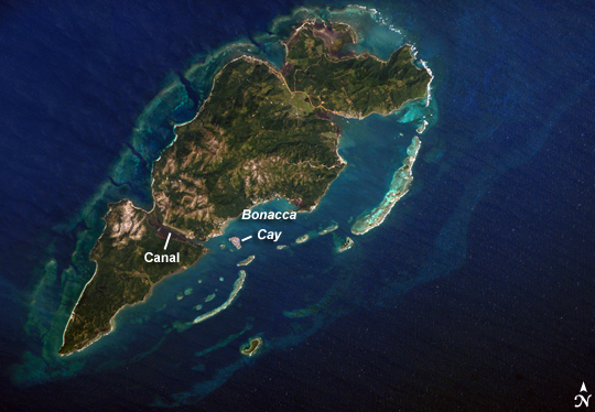 |
| Guanaja Island, Honduras: Guanaja Island is located in the western Caribbean, approximately 60 kilometers (about 37 miles) north of mainland Honduras. The island is near the western edge of the Cayman Ridge, a topographic feature made of rock types that indicate ancient volcanic islands, sedimentary layers, and ocean crust. The ridge resulted from tectonic interactions between the North American, South American, and Caribbean Plates. Guanaja and the nearby islands of Roatan and Utila (not shown) are the only portions of the western Cayman Ridge currently exposed above water. The island is notable for being largely undeveloped--the exception being highly concentrated development on Bonacca Cay, a small island (roughly 0.5 by 0.3 kilometers) located along the southeastern coastline of the main island. The main island has little in the way of roads or other infrastructure--a canal is the major means of traversing the island--making it an attractive destination for hikers and eco-tourists. The clear waters and reefs that almost completely encircle Guanaja also attract divers. In 1998, Hurricane Mitch destroyed almost all of the island's mangrove forests, devastating coastal habitats and causing soil erosion. Regeneration of mangroves is slow, and scientists have suggested active reseeding efforts as the only way to restore the forests. |
| Images: | All Available Images Low-Resolution 233k |
|
| Mission: | ISS014 |
|
| Roll - Frame: | E - 15767 |
|
| Geographical Name: | HONDURAS |
|
| Features: | ISLA DE GUANAJA, REEFS |
|
| Center Lat x Lon: | 16.5N x 85.9W |
|
| Film Exposure: | N=Normal exposure, U=Under exposed, O=Over exposed, F=out of Focus |
|
| Percentage of Cloud Cover-CLDP: | 10 |
|
| Camera:: | E4 |
|
| Camera Tilt: | 23 | LO=Low Oblique, HO=High Oblique, NV=Near Vertical |
| Camera Focal Length: | 400 |
|
| Nadir to Photo Center Direction: | SW | The direction from the nadir to the center point, N=North, S=South, E=East, W=West |
| Stereo?: | Y=Yes there is an adjacent picture of the same area, N=No there isn't |
|
| Orbit Number: | 3379 |
|
| Date: | 20070301 | YYYYMMDD |
| Time: | 155917 | GMT HHMMSS |
| Nadir Lat: | 17.4N |
Latitude of suborbital point of spacecraft |
| Nadir Lon: | 85W |
Longitude of suborbital point of spacecraft |
| Sun Azimuth: | 130 | Clockwise angle in degrees from north to the sun measured at the nadir point |
| Space Craft Altitude: | 183 | nautical miles |
| Sun Elevation: | 53 | Angle in degrees between the horizon and the sun, measured at the nadir point |
| Land Views: | EROSION, ISLAND |
|
| Water Views: | CANAL, OCEAN |
|
| Atmosphere Views: | |
|
| Man Made Views: | |
|
| City Views: | |
|
Photo is not associated with any sequences | ||
| NASA Home Page |
JSC Home Page |
JSC Digital Image Collection |
Earth Science & Remote Sensing |
|
This service is provided by the International Space Station program and the JSC Earth Science & Remote Sensing Unit, ARES Division, Exploration Integration Science Directorate.

|