
Geographic Region: VENEZUELA
Feature: MARACAIBO
|
Geographic Region: VENEZUELA Feature: MARACAIBO |
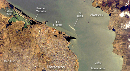 |
| Maracaibo City and Oil Slick, Venezuela: This astronaut photograph depicts the narrow (6-kilometer-wide) strait between Lake Maracaibo to the south and the Gulf of Venezuela to the north. This brackish lake in northern Venezuela is the largest in South America. The lake and its small basin sit on top of a vast reservoir of buried oil deposits, first tapped in 1914. Venezuela is now the world's fifth largest oil producer. The narrow strait has been deepened to allow ocean-going vessels access to the lake for oil transport. Shipping is one of the main sources of pollution in the lake; pollution enters the lake when when ships dump ballast and other waste. An oil slick, likely related to bilge pumping, can be seen as a bright streak northeast of El Triunfo in this image from February 23, 2007. Other sources of pollution to the lake include underwater oil pipeline leakage, untreated municipal and industrial waste from coastal cities, and runoff of chemicals from surrounding farm land. Deepening the narrow channel for shipping has also allowed saltwater intrusion into the lake, negatively affecting lake life. Since the discovery of oil, cities like Maracaibo have sprung up along the northwestern coastline of the lake. With satellite cities such as San Luis and El Triunfo (visible in this view), greater Maracaibo has a population of about 2.5 million. Just outside the lower margin of the picture, a major bridge spans the narrows pictured here, connecting cities such as Altagracia (top right) to Maracaibo.
|
| Images: | All Available Images Low-Resolution 228k |
|
| Mission: | ISS014 |
|
| Roll - Frame: | E - 14618 |
|
| Geographical Name: | VENEZUELA |
|
| Features: | MARACAIBO |
|
| Center Lat x Lon: | 10.7N x 71.6W |
|
| Film Exposure: | N=Normal exposure, U=Under exposed, O=Over exposed, F=out of Focus |
|
| Percentage of Cloud Cover-CLDP: | 10 |
|
| Camera:: | E4 |
|
| Camera Tilt: | 15 | LO=Low Oblique, HO=High Oblique, NV=Near Vertical |
| Camera Focal Length: | 400 |
|
| Nadir to Photo Center Direction: | SW | The direction from the nadir to the center point, N=North, S=South, E=East, W=West |
| Stereo?: | Y=Yes there is an adjacent picture of the same area, N=No there isn't |
|
| Orbit Number: | 3285 |
|
| Date: | 20070223 | YYYYMMDD |
| Time: | 170855 | GMT HHMMSS |
| Nadir Lat: | 11.3N |
Latitude of suborbital point of spacecraft |
| Nadir Lon: | 71W |
Longitude of suborbital point of spacecraft |
| Sun Azimuth: | 188 | Clockwise angle in degrees from north to the sun measured at the nadir point |
| Space Craft Altitude: | 185 | nautical miles |
| Sun Elevation: | 69 | Angle in degrees between the horizon and the sun, measured at the nadir point |
| Land Views: | BASIN |
|
| Water Views: | CHANNEL, GULF, LAKE, OCEAN, RESERVOIR, STRAIT |
|
| Atmosphere Views: | |
|
| Man Made Views: | POLLUTION |
|
| City Views: | MARACAIBO |
|
Photo is not associated with any sequences | ||
| NASA Home Page |
JSC Home Page |
JSC Digital Image Collection |
Earth Science & Remote Sensing |
|
This service is provided by the International Space Station program and the JSC Earth Science & Remote Sensing Unit, ARES Division, Exploration Integration Science Directorate.

|