
Geographic Region: URUGUAY
Feature: MONTEVIDEO METRO AREA
|
Geographic Region: URUGUAY Feature: MONTEVIDEO METRO AREA |
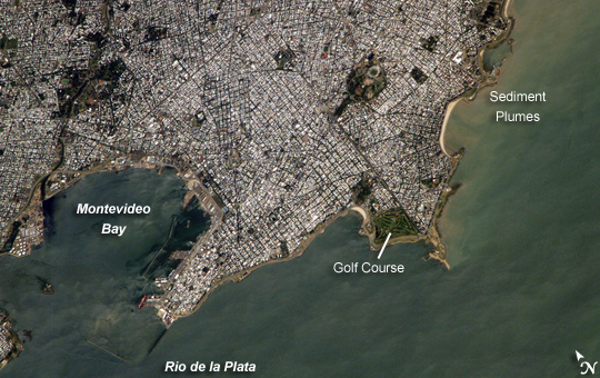 |
| ISS014-E-13598 (29 Jan. 2007) --- Montevideo, Uruguay is featured in this image photographed by an Expedition 14 crewmember on the International Space Station. Reflective roofing materials and dark asphalt streets outline the urban grid pattern of Uruguay's capital city of Montevideo in this image. The city may be viewed as a precursor of the predicted global population shift from dominantly rural to urban environments (by 2030, according to recent United Nations estimates) -- nearly half of Uruguay's total population now lives in the Montevideo metropolitan area. Located on the southern coastline of Uruguay along the Rio de la Plata, Montevideo Bay provides an important harbor and port facilities for transport of South American agricultural products. This view is of sufficient resolution (approximately 7 meters/pixel) to discriminate between dark green canopied tree cover and light green grass - important information for study of urban ecology and climate, as well as city water use planning - in a large golf course located at the southern edge of the city (near center right). Sediment plumes along the coastline to the southeast of the city are also visible; rough patterns in the water surface of Montevideo Bay and the Rio de la Plata are a combination of wind disturbance and sediments. Montevideo, Uruguay: Reflective roofing materials and dark asphalt streets outline the urban grid pattern of Uruguay's capital city, Montevideo, in this astronaut photograph. The city may be viewed as a precursor of a global population shift from dominantly rural to urban environments, a shift the United Nations estimates will occur by 2030. Nearly half of Uruguay's total population now lives in the Montevideo metropolitan area. Located on the southern coastline of Uruguay along the Rio de la Plata, Montevideo Bay provides an important harbor and port facilities for transport of South American agricultural products. This astronaut photograph has a resolution (resolution means "level of detail") of approximately 7 meters per pixel, which is detailed enough to tell dark green, canopied tree cover from light green grass in a large golf course located at the southern edge of the city (near image center right). That level of detail is important for studies of urban ecology and climate, as well as for city water use planning. Sediment plumes along the coastline to the southeast of the city are also visible; rough patterns in the water surface of Montevideo Bay and the Rio de la Plata are a combination of wind disturbance and sediments. |
| Images: | All Available Images Low-Resolution 275k |
|
| Mission: | ISS014 |
|
| Roll - Frame: | E - 13598 |
|
| Geographical Name: | URUGUAY |
|
| Features: | MONTEVIDEO METRO AREA |
|
| Center Lat x Lon: | 34.8S x 56.2W |
|
| Film Exposure: | N=Normal exposure, U=Under exposed, O=Over exposed, F=out of Focus |
|
| Percentage of Cloud Cover-CLDP: | 10 |
|
| Camera:: | E4 |
|
| Camera Tilt: | 39 | LO=Low Oblique, HO=High Oblique, NV=Near Vertical |
| Camera Focal Length: | 800 |
|
| Nadir to Photo Center Direction: | N | The direction from the nadir to the center point, N=North, S=South, E=East, W=West |
| Stereo?: | Y=Yes there is an adjacent picture of the same area, N=No there isn't |
|
| Orbit Number: | 2889 |
|
| Date: | 20070129 | YYYYMMDD |
| Time: | 161411 | GMT HHMMSS |
| Nadir Lat: | 37.2S |
Latitude of suborbital point of spacecraft |
| Nadir Lon: | 55.7W |
Longitude of suborbital point of spacecraft |
| Sun Azimuth: | 347 | Clockwise angle in degrees from north to the sun measured at the nadir point |
| Space Craft Altitude: | 183 | nautical miles |
| Sun Elevation: | 70 | Angle in degrees between the horizon and the sun, measured at the nadir point |
| Land Views: | |
|
| Water Views: | BAY, SEDIMENT |
|
| Atmosphere Views: | |
|
| Man Made Views: | HARBOR, PORT |
|
| City Views: | MONTEVIDEO |
|
Photo is not associated with any sequences | ||
| NASA Home Page |
JSC Home Page |
JSC Digital Image Collection |
Earth Science & Remote Sensing |
|
This service is provided by the International Space Station program and the JSC Earth Science & Remote Sensing Unit, ARES Division, Exploration Integration Science Directorate.

|