Geographic Region: NORTHERN MARIANA IS.
Feature: PAGAN, VOLCANOS, ASH PLUME
|
Geographic Region: NORTHERN MARIANA IS. Feature: PAGAN, VOLCANOS, ASH PLUME |
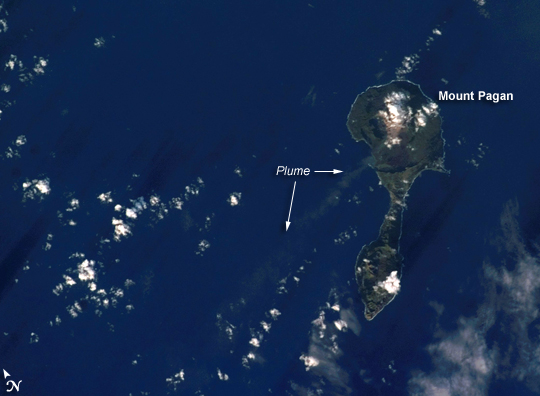 |
| Pagan Island, Northern Mariana Islands: The Mariana Islands are part a volcanic island arc--surface volcanoes formed from magma generated as one tectonic plate overrides another. In the case of the Mariana Islands, the Pacific Plate is being pulled, or subducted, beneath the Philippine Plate along the famously deep Mariana Trench, which is more than 11 kilometers (nearly 7 miles) below sea level. Pagan Island (image right) is made up of two volcanoes connected by a narrow isthmus of land. The volcanoes are stratovolcanoes, which are tall, typically cone-shaped structures formed by layers of dense, crystallized lava and less-dense ash and pumice. Mount Pagan, the larger of the two volcanoes, forms the northeastern portion of the island and has been the most active historically. The most recent major eruption took place in 1981, but since then numerous steam- and ash-producing events have been observed at the volcano--the latest reported one occurring between December 5-8, 2006. This astronaut photograph records volcanic activity on January 11, 2007, that produced a thin plume that extended westwards away from Mount Pagan. The plume was most probably steam, possibly with minor ash content. The island is sparsely populated, and it is monitored for volcanic activity by the United States Geological Survey and the Commonwealth of the Mariana Islands. |
| Images: | All Available Images Low-Resolution 156k |
|
| Mission: | ISS014 |
|
| Roll - Frame: | E - 11872 |
|
| Geographical Name: | NORTHERN MARIANA IS. |
|
| Features: | PAGAN, VOLCANOS, ASH PLUME |
|
| Center Lat x Lon: | 18.0N x 146.0E |
|
| Film Exposure: | N=Normal exposure, U=Under exposed, O=Over exposed, F=out of Focus |
|
| Percentage of Cloud Cover-CLDP: | 25 |
|
| Camera:: | E4 |
|
| Camera Tilt: | 19 | LO=Low Oblique, HO=High Oblique, NV=Near Vertical |
| Camera Focal Length: | 180 |
|
| Nadir to Photo Center Direction: | E | The direction from the nadir to the center point, N=North, S=South, E=East, W=West |
| Stereo?: | Y=Yes there is an adjacent picture of the same area, N=No there isn't |
|
| Orbit Number: | 2599 |
|
| Date: | 20070111 | YYYYMMDD |
| Time: | 065721 | GMT HHMMSS |
| Nadir Lat: | 18.1N |
Latitude of suborbital point of spacecraft |
| Nadir Lon: | 145.0E |
Longitude of suborbital point of spacecraft |
| Sun Azimuth: | 242 | Clockwise angle in degrees from north to the sun measured at the nadir point |
| Space Craft Altitude: | 180 | nautical miles |
| Sun Elevation: | 13 | Angle in degrees between the horizon and the sun, measured at the nadir point |
| Land Views: | ISLAND, VOLCANO |
|
| Water Views: | SEA |
|
| Atmosphere Views: | PLUME |
|
| Man Made Views: | |
|
| City Views: | |
|
Photo is not associated with any sequences | ||
| NASA Home Page |
JSC Home Page |
JSC Digital Image Collection |
Earth Science & Remote Sensing |
|
This service is provided by the International Space Station program and the JSC Earth Science & Remote Sensing Unit, ARES Division, Exploration Integration Science Directorate.

|