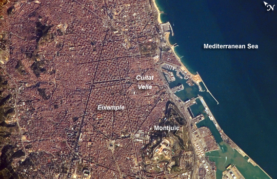
 Photo #: ISS014-E-10547 Date: Dec. 2006
Geographic Region: SPAIN
Feature: CENTRAL BARCELONA, HARBOR

 Photo #: ISS014-E-10547 Date: Dec. 2006 Photo #: ISS014-E-10547 Date: Dec. 2006Geographic Region: SPAIN Feature: CENTRAL BARCELONA, HARBOR |
 |
| Barcelona, Spain: Barcelona, Spain, occupies a low plateau along the Mediterranean coastal plain. The city is the second largest in Spain (after the capital, Madrid), and it hosts the country's largest seaport, portions of which are visible in the lower right of the image. This detailed astronaut photograph captures several notable features of the Barcelona urban landscape. (A regional view of the city is available in a previously published astronaut photograph.) The architectural design of the Eixample district (image center) displays a grid pattern distinctive for Barcelona. Built during the 19th and 20th centuries, the district was built with octagonal city blocks--rectangular blocks with the corners cut off. (At the level of detail of this photograph, the blocks appear to be squares.) The original intention was for buildings to occupy only two or three sides of the octagonal blocks, surrounding gardens and open space. While the original street grid pattern remains, today many of the octagonal blocks are completely built up. The adjacent Cuitat Vella, or "old city," presents a much denser building pattern, which dates from Roman times. Also visible at image lower right is the 173-meter-high Montjuic mountain--historically, the location of fortresses due to its strategic position overlooking the city's harbor. Light tan and orange structures visible at the crest of the mountain include the stadium and other buildings used in the 1992 Summer Olympic Games. |
| Images: | All Available Images Low-Resolution 290k |
|
| Mission: | ISS014 |
|
| Roll - Frame: | E - 10547 |
|
| Geographical Name: | SPAIN |
|
| Features: | CENTRAL BARCELONA, HARBOR |
|
| Center Lat x Lon: | 41.4N x 2.2E |
|
| Film Exposure: | N=Normal exposure, U=Under exposed, O=Over exposed, F=out of Focus |
|
| Percentage of Cloud Cover-CLDP: | 10 |
|
| Camera:: | E4 |
|
| Camera Tilt: | 24 | LO=Low Oblique, HO=High Oblique, NV=Near Vertical |
| Camera Focal Length: | 800 |
|
| Nadir to Photo Center Direction: | NE | The direction from the nadir to the center point, N=North, S=South, E=East, W=West |
| Stereo?: | Y=Yes there is an adjacent picture of the same area, N=No there isn't |
|
| Orbit Number: | 2414 |
|
| Date: | 20061230 | YYYYMMDD |
| Time: | 130722 | GMT HHMMSS |
| Nadir Lat: | 40.3N |
Latitude of suborbital point of spacecraft |
| Nadir Lon: | 1.5E |
Longitude of suborbital point of spacecraft |
| Sun Azimuth: | 198 | Clockwise angle in degrees from north to the sun measured at the nadir point |
| Space Craft Altitude: | 173 | nautical miles |
| Sun Elevation: | 25 | Angle in degrees between the horizon and the sun, measured at the nadir point |
| Land Views: | MOUNTAIN, PLAIN, PLATEAU |
|
| Water Views: | |
|
| Atmosphere Views: | |
|
| Man Made Views: | HARBOR |
|
| City Views: | BARCELONA |
|
Photo is not associated with any sequences | ||
| NASA Home Page |
JSC Home Page |
JSC Digital Image Collection |
Earth Science & Remote Sensing |
|
|