Geographic Region: BRAZIL
Feature: STRANDPLAIN,AIRPORT,CARAVELAS
|
Geographic Region: BRAZIL Feature: STRANDPLAIN,AIRPORT,CARAVELAS |
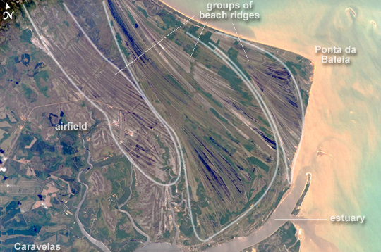 |
| Caravelas Strandplain, Bahia Province, Brazil This astronaut photograph highlights an ancient shoreline, or strandplain, on the coast of Brazil. The image is dominated by numerous fine, parallel lines (trending diagonally from upper left to lower right), each of which is an ancient shoreline made up of sand transported from rivers to the north. The strandplain grew as the narrow shorelines accumulated line by line, in their dozens or even hundreds, over thousands of years. The shorelines group into "packets" with different orientations (outlined in white) that indicate their relative ages. Younger packets cut into or overlie older packets. Based on those relationships, the packet nearest the coast (farthest right) is the youngest, while the packet north of the city of Caravelas is the oldest (image bottom). The Caravelas River flows into the Atlantic Ocean at the bottom of the view. Sediment from this river and the current shoreline produces the light browns and dun colors visible offshore. On the day the astronaut took this image, the river water was relatively clear; clear water (gray) flows out of the main river mouth and also off to one side to the south, over a levee. The Caravelas airport appears near the middle of the view, and is built on one of the ancient shoreline packets. Caravelas itself, a fishing town of about 20,000 residents, lies on an estuary and was once a flourishing whaling center--the prominent cape at image top right is known as Ponta da Baleia (Whale Point). |
| Images: | All Available Images Low-Resolution 234k |
|
| Mission: | ISS014 |
|
| Roll - Frame: | E - 10499 |
|
| Geographical Name: | BRAZIL |
|
| Features: | STRANDPLAIN,AIRPORT,CARAVELAS |
|
| Center Lat x Lon: | 17.7S x 39.2W |
|
| Film Exposure: | N=Normal exposure, U=Under exposed, O=Over exposed, F=out of Focus |
|
| Percentage of Cloud Cover-CLDP: | 10 |
|
| Camera:: | E4 |
|
| Camera Tilt: | 22 | LO=Low Oblique, HO=High Oblique, NV=Near Vertical |
| Camera Focal Length: | 400 |
|
| Nadir to Photo Center Direction: | E | The direction from the nadir to the center point, N=North, S=South, E=East, W=West |
| Stereo?: | Y=Yes there is an adjacent picture of the same area, N=No there isn't |
|
| Orbit Number: | 2304 |
|
| Date: | 20061223 | YYYYMMDD |
| Time: | 145725 | GMT HHMMSS |
| Nadir Lat: | 18.1S |
Latitude of suborbital point of spacecraft |
| Nadir Lon: | 40.3W |
Longitude of suborbital point of spacecraft |
| Sun Azimuth: | 215 | Clockwise angle in degrees from north to the sun measured at the nadir point |
| Space Craft Altitude: | 178 | nautical miles |
| Sun Elevation: | 83 | Angle in degrees between the horizon and the sun, measured at the nadir point |
| Land Views: | CAPE, COAST |
|
| Water Views: | ESTUARY, OCEAN, RIVER, SEDIMENT |
|
| Atmosphere Views: | |
|
| Man Made Views: | AIRPORT |
|
| City Views: | |
|
Photo is not associated with any sequences | ||
| NASA Home Page |
JSC Home Page |
JSC Digital Image Collection |
Earth Science & Remote Sensing |
|
This service is provided by the International Space Station program and the JSC Earth Science & Remote Sensing Unit, ARES Division, Exploration Integration Science Directorate.

|